IMAGES TAKEN NEAR TO
BALLINDALLOCH, AB37 9AL
Introduction
This page details the photographs taken nearby to AB37 9AL by members of the Geograph project.
The Geograph project started in 2005 with the aim of publishing, organising and preserving representative images for every square kilometre of Great Britain, Ireland and the Isle of Man.

There are currently over 7.5m images from over14,400 individuals and you can help contribute to the project by visiting https://www.geograph.org.uk
Image Map
Images are licensed for reuse under creativecommons.org/licenses/by-sa/2.0
Notes
- Clicking on the map will re-center to the selected point.
- The higher the marker number, the further away the image location is from the centre of the postcode.
Image Listing (12 Images Found)
Images are licensed for reuse under creativecommons.org/licenses/by-sa/2.0
Image
Details
Distance
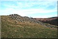
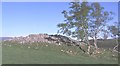
2
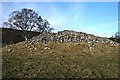
Carn a'Bhodaich
There were originally three cairns here, and this is the sole survivor. See http://www.rcahms.gov.uk/pls/portal/canmore.newcandig_details_gis?inumlink=16028 for full details.
Image: © Anne Burgess
Taken: 18 Jan 2009
0.12 miles
3
Carn a'Bhodaich
This is the view of the cairn from the top of the stony slope in Image The name is Gaelic and translates as 'The Old Man's Cairn'. See http://www.rcahms.gov.uk/pls/portal/canmore.newcandig_details_gis?inumlink=16028 for the archaeological description.
Image: © Anne Burgess
Taken: 18 Jan 2009
0.13 miles
4
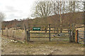
Entrance to Shenval Wood
The start of a landrover track going up to moorland east of Creag an Tarmachain.
Image: © Dorothy Carse
Taken: 16 Mar 2013
0.13 miles
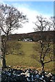
5
Cairn near Chapelton
This pile of stones is separated from Carn a'Bhodaich by a few metres of grass, and I am unsure whether this is part of the original cairn or not. See http://www.rcahms.gov.uk/pls/portal/canmore.newcandig_details_gis?inumlink=16028
Image: © Anne Burgess
Taken: 18 Jan 2009
0.15 miles
6
Shenval of Kilnmaichlie
The name Shenval occurs quite commonly in this part of Banffshire. It is from Gaelic 'Seana Bhaile' which means 'Old Farm'. This particular one is in the parish of Inveravon, and is not to be confused with Shenvals in grid squares NJ2129, NJ2638 and NJ3630, never mind with similarly named places further afield.
Image: © Anne Burgess
Taken: 18 Jan 2009
0.16 miles
7
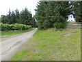
Minor road at Shenval
Looking north-eastward.
Image: © Peter Wood
Taken: 6 Jul 2020
0.16 miles
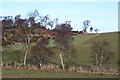
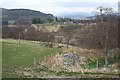
8
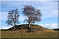
Chapelton
Looking from the top of the ancient cairn, the house is framed by the birches which grow from the foot of the cairn.
Image: © Anne Burgess
Taken: 18 Jan 2009
0.16 miles
9
Chapelton Cairn
This isn't just a pile of stones, it is a prehistoric cairn. See http://www.rcahms.gov.uk/pls/portal/canmore.newcandig_details_gis?inumlink=16028 for details.
Image: © Anne Burgess
Taken: Unknown
0.18 miles
10
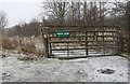
The chapel ruins and the chapel well are enclosed by the fence on the right
Image: © Des Colhoun
Taken: 23 Apr 2008
0.20 miles