IMAGES TAKEN NEAR TO
STRATHDON, AB36 8UQ
Introduction
This page details the photographs taken nearby to AB36 8UQ by members of the Geograph project.
The Geograph project started in 2005 with the aim of publishing, organising and preserving representative images for every square kilometre of Great Britain, Ireland and the Isle of Man.

There are currently over 7.5m images from over14,400 individuals and you can help contribute to the project by visiting https://www.geograph.org.uk
Image Map
Images are licensed for reuse under creativecommons.org/licenses/by-sa/2.0
Notes
- Clicking on the map will re-center to the selected point.
- The higher the marker number, the further away the image location is from the centre of the postcode.
Image Listing (26 Images Found)
Images are licensed for reuse under creativecommons.org/licenses/by-sa/2.0
Image
Details
Distance
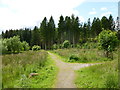
2
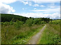
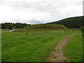
Path near Doune of Invernochty
Towards an area of woodland named The Claisneen (from Gaelic 'Clais Nighinne' - hollow of the maiden).
Image: © Alan O'Dowd
Taken: 22 Jul 2015
0.14 miles
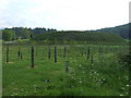
4
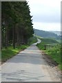
Don't get lost on the way to Lost
Lost seems to be the name of a farm about 600 m up the road, just visible in the distance.
Image: © Bill Harrison
Taken: 28 Apr 2019
0.17 miles
5
Path junction, The Claisneen
This area of woodland is marked on the large scale plan as The Claisneen (from Gaelic 'Clais Nighinne' - hollow of the maiden).
Image: © Alan O'Dowd
Taken: 22 Jul 2015
0.18 miles
6
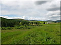
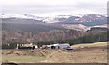
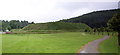
View up Glen Nochty from Doune of Invernochty
Looking towards the farm of Lost from the top of the ancient motte.
Image: © Alan O'Dowd
Taken: 22 Jul 2015
0.19 miles
7
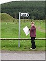
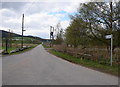
Still lost!
Since Peter Ward's photo taken in 1989, things have become even more confusing as either the sign has moved or the fir trees have. Does every 'geograph' contributor have to pose with the OS map?
Image: © Gordon Hatton
Taken: 7 Aug 2008
0.21 miles
8
Doune of Invernochty
http://ads.ahds.ac.uk/catalogue/adsdata/PSAS_2002/pdf/vol_053/53_034_045.pdf
Image: © Stanley Howe
Taken: 11 Jun 2007
0.22 miles
9
Doune of Invernochty
This large and rather splendid motte was extended and fortified by the Earl of Mar in the 12th century, but seems to have had a relatively short life as the earl moved on to a fine stone castle at Kildrummy a century later.
Image: © Gordon Hatton
Taken: 7 Aug 2008
0.22 miles
10
Doune of Invernochty
An earthen castle mound, dating from the 12th century.
Image: © Carron K
Taken: 15 Aug 2015
0.22 miles