IMAGES TAKEN NEAR TO
Birkhall, BALLATER, AB35 5SQ
Introduction
This page details the photographs taken nearby to AB35 5SQ by members of the Geograph project.
The Geograph project started in 2005 with the aim of publishing, organising and preserving representative images for every square kilometre of Great Britain, Ireland and the Isle of Man.

There are currently over 7.5m images from over14,400 individuals and you can help contribute to the project by visiting https://www.geograph.org.uk
Image Map
Images are licensed for reuse under creativecommons.org/licenses/by-sa/2.0
Notes
- Clicking on the map will re-center to the selected point.
- The higher the marker number, the further away the image location is from the centre of the postcode.
Image Listing (22 Images Found)
Images are licensed for reuse under creativecommons.org/licenses/by-sa/2.0
Image
Details
Distance
1
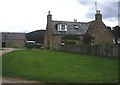
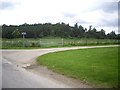
Dalliefour farmhouse
Seen from the entrance off the B976.
Image: © Stanley Howe
Taken: 6 Jul 2012
0.00 miles
2
Approach to Dalliefour Farm
Along the B976.
Image: © Stanley Howe
Taken: 6 Jul 2012
0.00 miles
3
Entrance sign to 'Dallyfour'
On OS maps the Farm is spelled Dalliefour, but the Cottage some distance beyond is Dallyfour.
Image: © Stanley Howe
Taken: 6 Jul 2012
0.02 miles
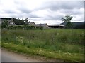
5
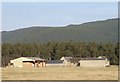
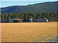
Dalliefour Farm
The farm stands on one of the former flood plains of the River Dee, now well above the level of the river, which has cut down through its former levels. In the background is part of the ridge to the south of the Dee Valley.
Image: © Anne Burgess
Taken: 3 Sep 2014
0.05 miles
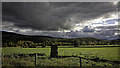
7
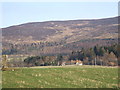
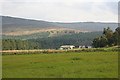
View from near Dallyfour
A standing stone (left), Milton of Brackley (centre), and the slopes of Cairn Leuchan (rising to 699m) behind.
Image: © Stanley Howe
Taken: 24 Mar 2007
0.06 miles
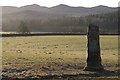
8
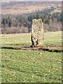
Scurriestone
A standing stone in a field by Dallyfour.
Image: © Stanley Howe
Taken: 24 Mar 2007
0.06 miles