IMAGES TAKEN NEAR TO
Court Drive, AB34 5FF
Introduction
This page details the photographs taken nearby to Court Drive, AB34 5FF by members of the Geograph project.
The Geograph project started in 2005 with the aim of publishing, organising and preserving representative images for every square kilometre of Great Britain, Ireland and the Isle of Man.

There are currently over 7.5m images from over14,400 individuals and you can help contribute to the project by visiting https://www.geograph.org.uk
Image Map
Images are licensed for reuse under creativecommons.org/licenses/by-sa/2.0
Notes
- Clicking on the map will re-center to the selected point.
- The higher the marker number, the further away the image location is from the centre of the postcode.
Image Listing (4 Images Found)
Images are licensed for reuse under creativecommons.org/licenses/by-sa/2.0
Image
Details
Distance
1
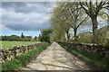
Fields to the left, houses to the right
A large new housing development to the west of the B9094 road just visible in the distance.
Image: © Bill Harrison
Taken: 29 May 2021
0.17 miles
2
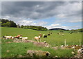
Cows in their field
Sunshine illuminates a herd of cows with Mortlich hill looming in the distance. 'Mortlich' appropriately enough means 'big hill' according to Celtic Place-names in Aberdeenshire by John Milne.
Image: © Bill Harrison
Taken: 29 May 2021
0.19 miles
4
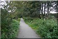
Railway trackbed, Aboyne
Now passing through a residential area after recent house building.
Image: © Richard Webb
Taken: 14 Sep 2019
0.23 miles