IMAGES TAKEN NEAR TO
Keig, ALFORD, AB33 8BX
Introduction
This page details the photographs taken nearby to AB33 8BX by members of the Geograph project.
The Geograph project started in 2005 with the aim of publishing, organising and preserving representative images for every square kilometre of Great Britain, Ireland and the Isle of Man.

There are currently over 7.5m images from over14,400 individuals and you can help contribute to the project by visiting https://www.geograph.org.uk
Image Map
Images are licensed for reuse under creativecommons.org/licenses/by-sa/2.0
Notes
- Clicking on the map will re-center to the selected point.
- The higher the marker number, the further away the image location is from the centre of the postcode.
Image Listing (14 Images Found)
Images are licensed for reuse under creativecommons.org/licenses/by-sa/2.0
Image
Details
Distance
1
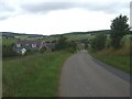
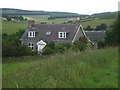
A cottage on the Hill of Airlie
Close to The Barmkyn hill fort.
Image: © Stanley Howe
Taken: 17 Jul 2008
0.02 miles
2
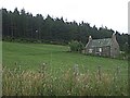
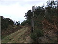
Northkeig Wood
Sheltering The Barmkyn.
Image: © Stanley Howe
Taken: 17 Jul 2008
0.08 miles
3
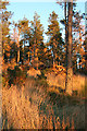
Wood of North Keig
Walking through this wood was not easy, because of large numbers of fallen trees, not to mention whins.
Image: © Anne Burgess
Taken: 3 Nov 2015
0.10 miles
4
Entrance to Wood of North Keig
The track gives access to the Wood of North Keig and Hill of Airlie upon which are the remains of the Barmkyn of Keig Neolithic fortified settlement [see http://www.geograph.org.uk/photo/1117119 ]. Tree felling operations were underway when the image was taken and a forester machine can be seen in the background.
Image: © Alison Mack
Taken: 11 Jan 2009
0.11 miles
5
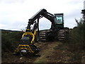
Forester Machine at Wood of North Keig
Tree felling operations were underway when the image was taken. The forester machine is sitting on a track that gives access to the Wood of North Keig and Hill of Airlie upon which are the remains of the Barmkyn of Keig Neolithic fortified settlement [see http://www.geograph.org.uk/photo/1117119 ].
Image: © Alison Mack
Taken: 11 Jan 2009
0.11 miles
8
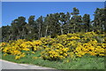
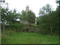
Looking up the Hill of Airlie
The hill is the site of an iron Age fort (see Canmore listing 17701: https://canmore.org.uk/site/17701/barmkyn-of-north-keig ) but impenetrable gorse faces onto the road.
Image: © Bill Harrison
Taken: 12 Jun 2021
0.13 miles
9
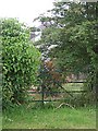
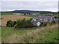
North Keig
Hiding behind what appears to be a rarely used gate.
Image: © Stanley Howe
Taken: 17 Jul 2008
0.13 miles