IMAGES TAKEN NEAR TO
Whitehouse, ALFORD, AB33 8AT
Introduction
This page details the photographs taken nearby to AB33 8AT by members of the Geograph project.
The Geograph project started in 2005 with the aim of publishing, organising and preserving representative images for every square kilometre of Great Britain, Ireland and the Isle of Man.

There are currently over 7.5m images from over14,400 individuals and you can help contribute to the project by visiting https://www.geograph.org.uk
Image Map
Images are licensed for reuse under creativecommons.org/licenses/by-sa/2.0
Notes
- Clicking on the map will re-center to the selected point.
- The higher the marker number, the further away the image location is from the centre of the postcode.
Image Listing (9 Images Found)
Images are licensed for reuse under creativecommons.org/licenses/by-sa/2.0
Image
Details
Distance
3
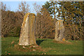
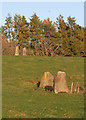
Druidsfield Standing Stones (3)
Two stones stand just outside the fence round the farm yard, and these two on the bank higher up. There is a suggestion that these two stones are the flankers of a recumbent stone circle, and that the recumbent was removed and built into the bank of the River Don. However the Royal Commission on the Ancient and Historic Monuments of Scotland does not quite ratify this suggestion. See http://canmore.org.uk/site/17519/druidstone-druidsfield for further details. Image]
Image: © Anne Burgess
Taken: 22 Oct 2015
0.22 miles
4

Druidsfield Standing Stones (4)
Two stones stand just outside the fence round the farm yard, and these two on the bank higher up. There is a suggestion that these two stones are the flankers of a recumbent stone circle, and that the recumbent was removed and built into the bank of the River Don. However the Royal Commission on the Ancient and Historic Monuments of Scotland does not quite ratify this suggestion. See http://canmore.org.uk/site/17519/druidstone-druidsfield for further details. Image]
Image: © Anne Burgess
Taken: 22 Oct 2015
0.22 miles
5
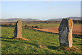
Druidsfield Standing Stones (5)
Two stones stand just outside the fence round the farm yard, and these two on the bank higher up, overlooking the Howe of Alford. There is a suggestion that these two stones are the flankers of a recumbent stone circle, and that the recumbent was removed and built into the bank of the River Don. However the Royal Commission on the Ancient and Historic Monuments of Scotland does not quite ratify this suggestion. See http://canmore.org.uk/site/17519/druidstone-druidsfield for further details. Image]
Image: © Anne Burgess
Taken: 22 Oct 2015
0.22 miles
6

Remains of a Monument?
In the long grass below the trees here are several large broken boulders. Are they erratics, or have they been cleared from the fields, or could they be remnants of some prehistoric monument, neighbours of the Image]?
Image: © Anne Burgess
Taken: 22 Oct 2015
0.23 miles
7

Montgarrie Stone Circle
This must have been quite a large Stone Circle, as far as I could tell these are the only 4 stones remaining. The stones are located to the rear of, the very aptly named, Druidsfield Farm, my guess is that this field is "The" Druidsfield.
Image: © Andrew Stuart
Taken: 10 Jun 2007
0.23 miles
8
Druidsfield Standing Stones (1)
Two stones stand just outside the fence round the farm yard, and two more on the bank higher up. There is a suggestion that the two upper stones are the flankers of a recumbent stone circle, and that the recumbent was removed and built into the bank of the River Don. However the Royal Commission on the Ancient and Historic Monuments of Scotland does not quite ratify this suggestion. See http://canmore.org.uk/site/17519/druidstone-druidsfield for further details. Image]
Image: © Anne Burgess
Taken: 22 Oct 2015
0.24 miles
9

Druidsfield Standing Stones (2)
Two stones stand just outside the fence round the farm yard, and two more on the bank higher up. There is a suggestion that the two upper stones are the flankers of a recumbent stone circle, and that the recumbent was removed and built into the bank of the River Don. However the Royal Commission on the Ancient and Historic Monuments of Scotland does not quite ratify this suggestion. See http://canmore.org.uk/site/17519/druidstone-druidsfield for further details. Image]
Image: © Anne Burgess
Taken: 22 Oct 2015
0.24 miles