IMAGES TAKEN NEAR TO
Clune View, BANCHORY, AB31 6BW
Introduction
This page details the photographs taken nearby to Clune View, AB31 6BW by members of the Geograph project.
The Geograph project started in 2005 with the aim of publishing, organising and preserving representative images for every square kilometre of Great Britain, Ireland and the Isle of Man.

There are currently over 7.5m images from over14,400 individuals and you can help contribute to the project by visiting https://www.geograph.org.uk
Image Map
Images are licensed for reuse under creativecommons.org/licenses/by-sa/2.0
Notes
- Clicking on the map will re-center to the selected point.
- The higher the marker number, the further away the image location is from the centre of the postcode.
Image Listing (8 Images Found)
Images are licensed for reuse under creativecommons.org/licenses/by-sa/2.0
Image
Details
Distance
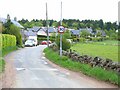
2
Durris School
Actually in the hamlet of Woodlands and formerly called Woodlands School, but renamed when Woodlands and Crossroads Primary Schools were merged in 2000. School roll in 2016-17: 41 pupils in two classes.
Image: © Bill Harrison
Taken: 6 Aug 2017
0.04 miles
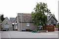
3
Durris School
Durris Primary School at the Woodlands of Durris.
Image: © Scott Cormie
Taken: 3 Jun 2022
0.04 miles
4
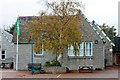
Woodlands School
The primary at Woodlands from the roadside.
Image: © Andrew Wood
Taken: 24 Oct 2016
0.05 miles
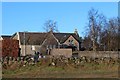
5
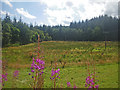
Rough meadow with native and plantation woodlands beyond
The foreground features the ubiquitous Rosebay willow herb in bloom. Photograph is taken from the roadway verge.
Image: © C Michael Hogan
Taken: 6 Aug 2009
0.13 miles
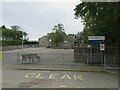
6
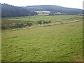
Sprawling low lying fields
Photographer is standing atop a hedgerow beside a minor road.
Image: © C Michael Hogan
Taken: 6 Aug 2009
0.20 miles
7
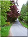
Road alongside Woodlands Park
The copper beech adds a touch of variety.
Image: © Oliver Dixon
Taken: 27 May 2006
0.20 miles