IMAGES TAKEN NEAR TO
Elmbank Terrace, ABERDEEN, AB24 3PD
Introduction
This page details the photographs taken nearby to Elmbank Terrace, AB24 3PD by members of the Geograph project.
The Geograph project started in 2005 with the aim of publishing, organising and preserving representative images for every square kilometre of Great Britain, Ireland and the Isle of Man.

There are currently over 7.5m images from over14,400 individuals and you can help contribute to the project by visiting https://www.geograph.org.uk
Image Map
Images are licensed for reuse under creativecommons.org/licenses/by-sa/2.0
Notes
- Clicking on the map will re-center to the selected point.
- The higher the marker number, the further away the image location is from the centre of the postcode.
Image Listing (98 Images Found)
Images are licensed for reuse under creativecommons.org/licenses/by-sa/2.0
Image
Details
Distance
2
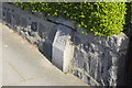
March Stone No. 58, Elmbank Terrace, Aberdeen
The March Stones mark the "Freedom Lands and Marches of Aberdeen." For their history, see the excellent guide produced by the City of Aberdeen: http://www.aberdeencity.gov.uk/web/files/LocalHistory/march_stones_01.pdf . There was a march (boundary) stone here in 1780 (long before housing was built), but the present stone dates from the 1920s. Most of the stones, including this one, are B-listed: http://www.britishlistedbuildings.co.uk/sc-20038-march-stone-no-58-in-front-garden-wall-of
Image: © Bill Harrison
Taken: 8 Sep 2012
0.04 miles
4
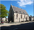
Former Powis Church
Built 1895 at the converging junction of George Street and Causewayend as a chapel of ease for Old Machar Cathedral (St Machar's Cathedral) and elevated to full-parish status by the Court of Teinds (Tithes) in 1904. In its heyday it facilitated "aggressive evangelism" and open-air services in the surrounding working-class slums, now long demolished. Now converted to flats.
See http://canmore.rcahms.gov.uk/en/site/178874/details/aberdeen+george+street+powis+parish+church/
Image: © Bill Harrison
Taken: 26 May 2013
0.07 miles
5
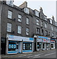
Shops + flats, George Street, Aberdeen
Shops with flats above at the very top end of George Street: a couple of independent computer shops and one of Aberdeen's less likely emporia, a marijuana paraphernalia store ("over 18s only"). It certainly results in less "crime and disorder" than the bars and nightclubs in the city centre. In terms of tags, I think we are still just about in the city centre rather than the suburbs.
Image: © Bill Harrison
Taken: 21 Sep 2013
0.07 miles
6
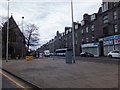
George Street, Aberdeen
From the junction with Powis Place
Image: © Alpin Stewart
Taken: 6 Apr 2014
0.08 miles
7
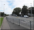
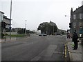
Powis Place/Causewayend, Aberdeen
Powis Place, which changes name to Causewayend about half way down, was turned into a dual carriageway in the 1960s amid wholescale residential demolition. The former Powis Church (now flats) lurks behind the trees in the right foreground and the cupola of St Stephen's Church (originally Causewayend Free Church) is just visible in the background.
Image: © Bill Harrison
Taken: 21 Sep 2013
0.08 miles
8
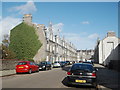
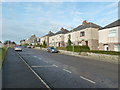
Granite suburban (Elmbank Road, Aberdeen)
Fine granite terraces dating from around 1900 and still looking as good as new.
Image: © Bill Harrison
Taken: 18 Oct 2014
0.08 miles
9
Powis Place / George Street junction, Aberdeen
Powis Place (left) and the foreground road are part of the A96 Aberdeen to Inverness road.
Image: © Richard Webb
Taken: 3 Aug 2011
0.08 miles
10
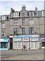
Aberdeen - Computer Warehouse
A sorry looking closed shop at the top of George Street. Above the street level shops are flats within traditional Aberdeen granite tenements.
www.aberdeencity.gov.uk
Image: © Colin Smith
Taken: 8 May 2014
0.08 miles