IMAGES TAKEN NEAR TO
Belhelvie, ABERDEEN, AB23 8WT
Introduction
This page details the photographs taken nearby to AB23 8WT by members of the Geograph project.
The Geograph project started in 2005 with the aim of publishing, organising and preserving representative images for every square kilometre of Great Britain, Ireland and the Isle of Man.

There are currently over 7.5m images from over14,400 individuals and you can help contribute to the project by visiting https://www.geograph.org.uk
Image Map
Images are licensed for reuse under creativecommons.org/licenses/by-sa/2.0
Notes
- Clicking on the map will re-center to the selected point.
- The higher the marker number, the further away the image location is from the centre of the postcode.
Image Listing (7 Images Found)
Images are licensed for reuse under creativecommons.org/licenses/by-sa/2.0
Image
Details
Distance
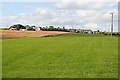
2
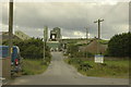
Balmedia Quarry
And the access road into it at Belhelvie.
Image: © Steven Brown
Taken: 29 Jul 2007
0.14 miles
6
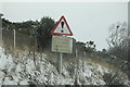
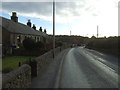
Road Sign
An interesting sign on the minor road passing Belhelvie Quarry.
Image: © Bill Harrison
Taken: 20 Dec 2009
0.23 miles
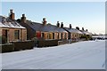
7
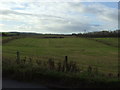
Balmedie
A field of grass by the road at Balmedie. In the background, in the next square, is Hill of Keir; on the left is the former schoolhouse, now boarded up, and on the left some of the new housing which has sprung up in recent years.
Image: © Anne Burgess
Taken: 27 Aug 2007
0.24 miles