IMAGES TAKEN NEAR TO
Laurel Terrace, ABERDEEN, AB22 8YX
Introduction
This page details the photographs taken nearby to Laurel Terrace, AB22 8YX by members of the Geograph project.
The Geograph project started in 2005 with the aim of publishing, organising and preserving representative images for every square kilometre of Great Britain, Ireland and the Isle of Man.

There are currently over 7.5m images from over14,400 individuals and you can help contribute to the project by visiting https://www.geograph.org.uk
Image Map
Images are licensed for reuse under creativecommons.org/licenses/by-sa/2.0
Notes
- Clicking on the map will re-center to the selected point.
- The higher the marker number, the further away the image location is from the centre of the postcode.
Image Listing (6 Images Found)
Images are licensed for reuse under creativecommons.org/licenses/by-sa/2.0
Image
Details
Distance
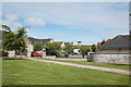
1
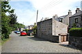
Victorian cottages
These 19th Century granite cottages with distinctive large outhouses are now surrounded by 1970s suburban housing. They maybe once had something to do with Danestone House, a couple of hundred metres to the north?
Image: © Bill Harrison
Taken: 12 Jun 2016
0.15 miles
2
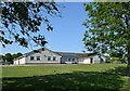
Denestone Primary School
An unusual design, which looks more like a house than a school. School roll 2022-23: 214 (estimated).
Image: © Bill Harrison
Taken: 13 Jun 2023
0.20 miles
3
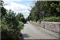
Lane in the city
The rustic setting is a bit deceptive, as suburban houses are all around...
Image: © Bill Harrison
Taken: 12 Jun 2016
0.21 miles
4

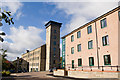
Suburban redevelopment
Former private road laid with granite setts, which once served Grandholm textile mill, now redeveloped as up-market housing.
Image: © Bill Harrison
Taken: 12 Jun 2016
0.22 miles
6
Suburban scene
Edge of the Grandholm estate.
Image: © Bill Harrison
Taken: 12 Jun 2016
0.24 miles