IMAGES TAKEN NEAR TO
North Deeside Road, MILLTIMBER, AB13 0AJ
Introduction
This page details the photographs taken nearby to North Deeside Road, AB13 0AJ by members of the Geograph project.
The Geograph project started in 2005 with the aim of publishing, organising and preserving representative images for every square kilometre of Great Britain, Ireland and the Isle of Man.

There are currently over 7.5m images from over14,400 individuals and you can help contribute to the project by visiting https://www.geograph.org.uk
Image Map
Images are licensed for reuse under creativecommons.org/licenses/by-sa/2.0
Notes
- Clicking on the map will re-center to the selected point.
- The higher the marker number, the further away the image location is from the centre of the postcode.
Image Listing (23 Images Found)
Images are licensed for reuse under creativecommons.org/licenses/by-sa/2.0
Image
Details
Distance
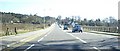
1
Milltimber West Development
Houses being built between the old Deeside Railway and Peterculter.
Image: © Richard Webb
Taken: 4 Apr 2017
0.10 miles
2
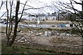
Milltimber West Development
Houses being built between the old Deeside Railway and Peterculter.
Image: © Richard Webb
Taken: 4 Apr 2017
0.10 miles
3
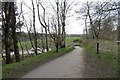
Deeside Way, Peterculter
A departure from the Deeside Railway trackbed due to a missing bridge over Pittengullies Brae.
Image: © Richard Webb
Taken: 4 Apr 2017
0.12 miles
4
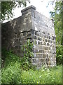
A road bridge abutment by the Old Deeside Railway track
The rail track is now the Deeside Way path.
Image: © Stanley Howe
Taken: 14 Jun 2013
0.12 miles
5
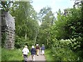
The Deeside Way, Peterculter
Passing between the abutments which are all that remain of the road bridge which once used to cross the Old Deeside Railway here.
Image: © Stanley Howe
Taken: 14 Jun 2013
0.12 miles
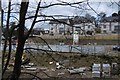
6
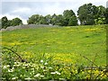
A flower meadow by the Dee
Looking up the brae from Lovers Walk path to an unidentified walled enclosure (on left). Since the former Deeside Railway used to run along the top of the brae - route marked by the line of trees - the enclosure may have had links with the railway. Indeed the map shows there to have been a short access bridge across the railtrack at that point, the stone abutments of which are still in place.
Image: © Stanley Howe
Taken: 14 Jun 2013
0.13 miles
7
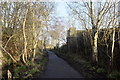
Deeside Way
The former bridge seems to have been for farm access.
Image: © Bill Harrison
Taken: 1 Jan 2020
0.13 miles
8
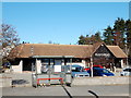
(The) Ploughman, Peterculter
A 'real pub' built in the 1960s
Image: © Bill Harrison
Taken: 28 Feb 2016
0.15 miles
9
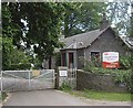
Access to Camphill School grounds
From Peterculter's 'Lovers Walk' at Pittengullies.
Image: © Stanley Howe
Taken: 14 Jun 2013
0.16 miles