IMAGES TAKEN NEAR TO
Banchory Devenick, ABERDEEN, AB12 5XN
Introduction
This page details the photographs taken nearby to AB12 5XN by members of the Geograph project.
The Geograph project started in 2005 with the aim of publishing, organising and preserving representative images for every square kilometre of Great Britain, Ireland and the Isle of Man.

There are currently over 7.5m images from over14,400 individuals and you can help contribute to the project by visiting https://www.geograph.org.uk
Image Map
Images are licensed for reuse under creativecommons.org/licenses/by-sa/2.0
Notes
- Clicking on the map will re-center to the selected point.
- The higher the marker number, the further away the image location is from the centre of the postcode.
Image Listing (19 Images Found)
Images are licensed for reuse under creativecommons.org/licenses/by-sa/2.0
Image
Details
Distance
1
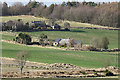
Tollohill
This is the farm marked as Tollohill on the modern maps, and one of two named on the first edition of the Ordnance Survey six-inch map, the other being Image I think the lower building may originally have been a mill.
Image: © Anne Burgess
Taken: 20 Mar 2020
0.05 miles
2
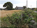
Tollohill
Field, overgrown dyke and a historic road across the lower reaches of The Mounth.
www.aberdeencity.gov.uk
Image: © Colin Smith
Taken: 6 Sep 2012
0.05 miles
3
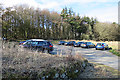
Tollohill Woods Car Park
A handy car park makes easy access to Tollohill Woods.
Image: © Anne Burgess
Taken: 20 Mar 2020
0.11 miles
4
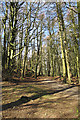
Tollohill Woods
One of the numerous paths in this small wood.
Image: © Anne Burgess
Taken: 20 Mar 2020
0.12 miles
5
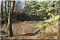
Former Quarry
The mid-19th century maps confirm my surmise that this hollow is a former quarry, though the geological map shows metamorphic bedrock here rather than granite.
Image: © Anne Burgess
Taken: 20 Mar 2020
0.13 miles
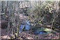
6
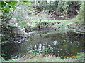
Disused quarry in Tollohill Wood.
Another water filled quarry in Tollohill Wood. There are several abandoned quarry workings in the wood.
Image: © George Wilson
Taken: 5 Oct 2006
0.14 miles
7
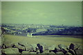
House on Tollohill, Aberdeen.
This is looking downhill and northwards towards Aberdeen. The river behind the farm is the Dee, with the mediaeval Brig o'Dee visible. Beyond is Aberdeen's skyline.
Image: © Colin Smith
Taken: Unknown
0.14 miles
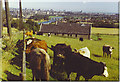
8
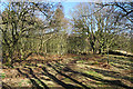
Path in Tollohill Woods
One of the smaller paths through the woods at Tollohill.
Image: © Anne Burgess
Taken: 20 Mar 2020
0.15 miles
9
Tollohill
Grassy fields and drystane dykes on Tollohill (or the Blue Hill) with sweeping view down to the Bridge of Dee and across to the city centre.
Image: © Colin Smith
Taken: 15 Aug 1986
0.15 miles
10
Flooded Quarry
This is one of several small ponds marked on the map, probably all flooded former quarries and rapidly becoming overgrown.
Image: © Anne Burgess
Taken: 20 Mar 2020
0.17 miles