IMAGES TAKEN NEAR TO
Deevale Road, ABERDEEN, AB12 5RP
Introduction
This page details the photographs taken nearby to Deevale Road, AB12 5RP by members of the Geograph project.
The Geograph project started in 2005 with the aim of publishing, organising and preserving representative images for every square kilometre of Great Britain, Ireland and the Isle of Man.

There are currently over 7.5m images from over14,400 individuals and you can help contribute to the project by visiting https://www.geograph.org.uk
Image Map
Images are licensed for reuse under creativecommons.org/licenses/by-sa/2.0
Notes
- Clicking on the map will re-center to the selected point.
- The higher the marker number, the further away the image location is from the centre of the postcode.
Image Listing (62 Images Found)
Images are licensed for reuse under creativecommons.org/licenses/by-sa/2.0
Image
Details
Distance
1
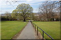
Path, Kincorth...
...connecting Kincorth Circle and Faulds Gate. The name Faulds Gate is said to derive from the Covenanters' Faulds, in memory of the Covenanting army who camped on Kincorth hill before the Battle of Bridge of Dee on 19th June 1639.
Image: © Bill Harrison
Taken: 19 Apr 2014
0.05 miles
2
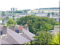
Kincorth from Ruthrieston
Kincorth was begun in the late 1930s as a garden suburb. Its streets follow the contours of Kincorth Hill and the housing scheme was a prize-winning one. The roofs in the foreground are in Ruthrieston Crescent.
Image: © Colin Smith
Taken: 6 Aug 2009
0.06 miles
3
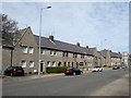
Faulds Gate, Kincorth
1930s Council houses, now mostly in private ownership.
Image: © Bill Harrison
Taken: 19 Apr 2014
0.08 miles
4
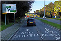
B9077, Great Southern Road, Ruthrieston
Image: © David Dixon
Taken: 24 Sep 2018
0.09 miles
5
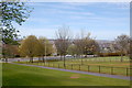
Kincorth green space
Kincorth council estate was laid out in the 1930s with lavish amounts of green space and must have been truly visionary at the time.
Image: © Bill Harrison
Taken: 19 Apr 2014
0.09 miles
6
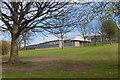
Abbotswell Primary School, Kincorth, Aberdeen
I guess this is the original 1930s primary school, built in Aberdeen granite on its hillside site.
Image: © Bill Harrison
Taken: 19 Apr 2014
0.10 miles
7
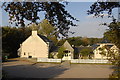
Suburban Carvery
The "Ghillie's Lair" at the southern end of the Brig o'Dee.
Image: © Bill Harrison
Taken: 15 Oct 2011
0.11 miles
8
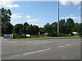
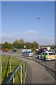
Large Roundabout on the A90 at the Bridge of Dee, Aberdeen
When travelling north along the A90 into Aberdeen, immediately you pass this roundabout, you cross the medieval Bridge of Dee.
Image: © G Laird
Taken: 17 Jul 2017
0.12 miles
10
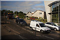
A90 at the Bridge of Dee roundabout, Aberdeen
The A90 is named Stonehaven Road at this point.
Image: © Mike Pennington
Taken: 10 Jun 2013
0.12 miles