IMAGES TAKEN NEAR TO
The Meadows, ABERDEEN, AB12 5GZ
Introduction
This page details the photographs taken nearby to The Meadows, AB12 5GZ by members of the Geograph project.
The Geograph project started in 2005 with the aim of publishing, organising and preserving representative images for every square kilometre of Great Britain, Ireland and the Isle of Man.

There are currently over 7.5m images from over14,400 individuals and you can help contribute to the project by visiting https://www.geograph.org.uk
Image Map
Images are licensed for reuse under creativecommons.org/licenses/by-sa/2.0
Notes
- Clicking on the map will re-center to the selected point.
- The higher the marker number, the further away the image location is from the centre of the postcode.
Image Listing (19 Images Found)
Images are licensed for reuse under creativecommons.org/licenses/by-sa/2.0
Image
Details
Distance
1
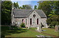
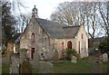
Maryculter Parish Kirk
The original kirk was built in 1787, and the south gable was added in the 1880s. See http://www.scottishchurches.org.uk/sites/site/id/3888/name/Maryculter+Parish+Church+Maryculter+Grampian for more details.
Image: © Anne Burgess
Taken: 20 May 2015
0.05 miles
2
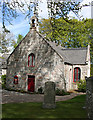
Maryculter Parish Kirk
The original kirk was built in 1787, and the south gable was added in the 1880s. See http://www.scottishchurches.org.uk/sites/site/id/3888/name/Maryculter+Parish+Church+Maryculter+Grampian for more details.
Image: © Anne Burgess
Taken: 20 May 2015
0.06 miles
4
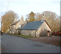
Camp Cottage, Kirkton of Maryculter
The former village schoolroom (possibly closed 2006?)
Image: © Bill Harrison
Taken: 29 Dec 2016
0.06 miles
5
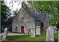
Kirkton of Maryculter Parish Church
The original building from 1786 with the south and north aisles added 1882. The communion table inside is said to incorporate a font. B-listed: http://portal.historicenvironment.scot/designation/LB16486 .
Image: © Bill Harrison
Taken: 29 Dec 2016
0.06 miles
6
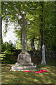
Maryculter War Memorial
The memorial stands in a shady spot just outside the kirk.
Image: © Anne Burgess
Taken: 20 May 2015
0.07 miles
7
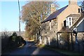
The road north out of Kirkton of Maryculter
Image: © Alan Reid
Taken: 18 Dec 2019
0.08 miles
8
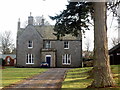
The auld manse, Kirkton of Maryculter
Built ca. 1868, now in private hands.
Image: © Bill Harrison
Taken: 29 Dec 2016
0.08 miles
9
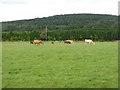
Pasture and forestry at Kirkton of Maryculter
Overlooking Storybook Glen, now known as 'The Glen and the Den', a theme park for children.http://www.storybookglenaberdeen.co.uk/.
Image: © M J Richardson
Taken: 18 Aug 2014
0.13 miles
10
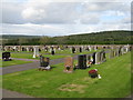
Cemetery at Kirkton of Maryculter
Looking east towards 'Storybook Glen'.
Image: © M J Richardson
Taken: 18 Aug 2014
0.15 miles