IMAGES TAKEN NEAR TO
Ladieside, SHETLAND, ZE2 9SX
Introduction
This page details the photographs taken nearby to Ladieside, ZE2 9SX by members of the Geograph project.
The Geograph project started in 2005 with the aim of publishing, organising and preserving representative images for every square kilometre of Great Britain, Ireland and the Isle of Man.

There are currently over 7.5m images from over14,400 individuals and you can help contribute to the project by visiting https://www.geograph.org.uk
Image Map
Images are licensed for reuse under creativecommons.org/licenses/by-sa/2.0
Notes
- Clicking on the map will re-center to the selected point.
- The higher the marker number, the further away the image location is from the centre of the postcode.
Image Listing (37 Images Found)
Images are licensed for reuse under creativecommons.org/licenses/by-sa/2.0
Image
Details
Distance
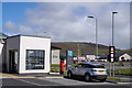
1
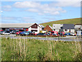
Central Garage, Brae
As seen from the Co-op car park.
Image: © Stuart Wilding
Taken: 13 May 2009
0.06 miles
2

The picture-winged fly Herina frondescentiae, Brae
Nicknamed the UN fly - look at the wings.
Image: © Mike Pennington
Taken: 1 Jul 2014
0.06 miles
3

The soldierfly Microchrysa polita, Brae
The only soldierfly found in Shetland until another species was found in Lerwick earlier this year.
Image: © Mike Pennington
Taken: 1 Jul 2014
0.06 miles
5
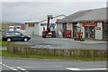
Garrock Bros Ltd (Plant and Skip Hire), Brae
Image: © David Dixon
Taken: 21 Sep 2018
0.08 miles
7
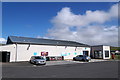
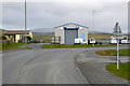
The Brae Co-op
When the old Brae store was acquired by the Co-op it was soon demolished and replaced with this new building.
Image: © Mike Pennington
Taken: 23 Jun 2017
0.11 miles
9
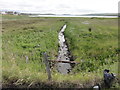
Stream at Brae
The small stream leading out sea at Brae. This is the probable location of an Ordnance Survey OSBM bolt, described as NBM OSBM BOLT C CONCRETE CUL 5.3M S SIDE RD 3.0M SW FENCE ANG (3.059m above Lerwick datum, 2nd order, new 1979).
The road and pavement have been redeveloped so possibly destroyed.
Image: © Mat Tuck
Taken: 3 Jul 2016
0.12 miles
10
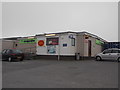
Brae: the Co-Op and post office
This large, well stocked store also contains the village post office. Behind the black car is the UK's northernmost Victorian postbox: see Image
Image: © Chris Downer
Taken: 11 Jul 2013
0.14 miles