IMAGES TAKEN NEAR TO
Sullom, SHETLAND, ZE2 9RD
Introduction
This page details the photographs taken nearby to ZE2 9RD by members of the Geograph project.
The Geograph project started in 2005 with the aim of publishing, organising and preserving representative images for every square kilometre of Great Britain, Ireland and the Isle of Man.

There are currently over 7.5m images from over14,400 individuals and you can help contribute to the project by visiting https://www.geograph.org.uk
Image Map
Images are licensed for reuse under creativecommons.org/licenses/by-sa/2.0
Notes
- Clicking on the map will re-center to the selected point.
- The higher the marker number, the further away the image location is from the centre of the postcode.
Image Listing (6 Images Found)
Images are licensed for reuse under creativecommons.org/licenses/by-sa/2.0
Image
Details
Distance
3
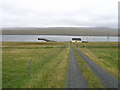
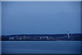
Smallholdings near Sullom Voe
Rural; atmosphere here is in total contract to the industrial activity at the oil terminal just across Sullom Voe.
Image: © James Allan
Taken: 8 May 2014
0.14 miles
4
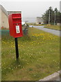
Sullom: postbox № ZE2 30
This small postbox, on the corner of a little cul-de-sac of modern houses, is emptied at 7 o'clock each morning except Sunday.
Image: © Chris Downer
Taken: 11 Jul 2013
0.18 miles
6
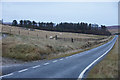
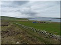
'The Gaza Strip', Sullom
This long strip plantation is next to a house called Gaza, hence the nickname, although it is more often referred to as Sullom plantation.
Image: © Mike Pennington
Taken: 25 Nov 2012
0.23 miles