IMAGES TAKEN NEAR TO
Upper Glebe, SHETLAND, ZE2 9EU
Introduction
This page details the photographs taken nearby to Upper Glebe, ZE2 9EU by members of the Geograph project.
The Geograph project started in 2005 with the aim of publishing, organising and preserving representative images for every square kilometre of Great Britain, Ireland and the Isle of Man.

There are currently over 7.5m images from over14,400 individuals and you can help contribute to the project by visiting https://www.geograph.org.uk
Image Map
Images are licensed for reuse under creativecommons.org/licenses/by-sa/2.0
Notes
- Clicking on the map will re-center to the selected point.
- The higher the marker number, the further away the image location is from the centre of the postcode.
Image Listing (15 Images Found)
Images are licensed for reuse under creativecommons.org/licenses/by-sa/2.0
Image
Details
Distance
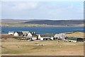
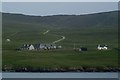
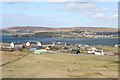
2
Glebe, Bressay
With the Ward of Bressay in the background.
Image: © Mike Pennington
Taken: 12 Oct 2011
0.02 miles
3
Ward of Bressay Walk
8 am ferry with Tricky Speirs, parked at bottom of track to walk up the Marilyn called Ward of Bressay.
Image: © Rude Health
Taken: 25 May 2013
0.05 miles
5
Glebe, Bressay
From the Aberdeen ferry; the track to the masts on the Ward of Bressay is in the background.
Image: © Mike Pennington
Taken: 5 Jul 2009
0.07 miles
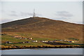
6
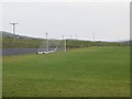
Football pitch, Bressay
Drained and flattened ground beside the road up Ward of Bressay.
Image: © Richard Webb
Taken: 12 Jul 2013
0.09 miles
7
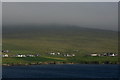
Glebe and Grindiscol, Bressay
The mist-clothed Ward of Bressay is in the background.
Image: © Mike Pennington
Taken: 7 Jul 2011
0.10 miles
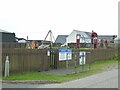
8
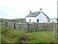
Cottage and livestock pens at Will Houll
Image: © Oliver Dixon
Taken: 14 Aug 2022
0.10 miles
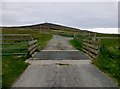
10
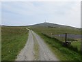
Road, Ward of Bressay
Serves the mast at the summit.
Image: © Richard Webb
Taken: 12 Jul 2013
0.11 miles