IMAGES TAKEN NEAR TO
Russell Crescent, SHETLAND, ZE1 0QT
Introduction
This page details the photographs taken nearby to Russell Crescent, ZE1 0QT by members of the Geograph project.
The Geograph project started in 2005 with the aim of publishing, organising and preserving representative images for every square kilometre of Great Britain, Ireland and the Isle of Man.

There are currently over 7.5m images from over14,400 individuals and you can help contribute to the project by visiting https://www.geograph.org.uk
Image Map
Images are licensed for reuse under creativecommons.org/licenses/by-sa/2.0
Notes
- Clicking on the map will re-center to the selected point.
- The higher the marker number, the further away the image location is from the centre of the postcode.
Image Listing (65 Images Found)
Images are licensed for reuse under creativecommons.org/licenses/by-sa/2.0
Image
Details
Distance
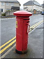
2
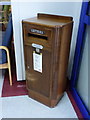
Lerwick: postbox № ZE1 65, Gilbert Bain Hospital
This lovely little wooden postbox stands just inside the main entrance of the Gilbert Bain Hospital. It would seem that it was originally a private facility made available to visitors, but has then been adopted into official service by Royal Mail - the notice below the slot reads:
THIS IS A PRIVATE POSTING BOX
LETTERS AND PACKETS POSTED IN IT WILL BE TREATED IN ALL RESPECTS AS POST LETTERS, BUT PROOF OF SUCH POSTING WILL NOT BE ACCEPTED IN LEGAL PROCEEDINGS AS EVIDENCE OF RECEIPT BY THE ADDRESSEE - By order of the Postmaster General.
It now has a proper information plate telling us that,like all boxes in Lerwick, there are two weekday 'final collection' times, one for off-islands next-day delivery (11:30am) and one for Shetland items (5:15pm). The single advertised Saturday collection is 3:15pm.
Image: © Chris Downer
Taken: 2 Aug 2011
0.05 miles
4
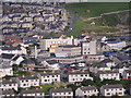
Lerwick taken from the top of the Bressay tower
Photo taken of Lerwick Harbour, during a radio survey at the Arqiva radio tower on Bressay.
Image: © Charlie Bell
Taken: 3 Feb 2010
0.09 miles
5
Lerwick: postbox № ZE1 63, Cairnfield Road
This George VI-reign postbox stands outside the Gilbert Bain Hospital and has a fire hydrant marker affixed to its back.
Like all boxes in Lerwick, there are two weekday 'final collection' times, one for off-islands next-day delivery (11:30am) and one for Shetland items (5:15pm). The single advertised Saturday collection is 3:15pm.
Image: © Chris Downer
Taken: 2 Aug 2011
0.10 miles
6
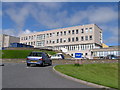
Gilbert Bain Hospital, Lerwick
The eastern end, at the corner of Gilbertson Road and South Road.
Image: © Mike Pennington
Taken: 28 Sep 2012
0.10 miles
7
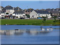
South Lochside Road, Lerwick
This main road runs round the central area of Lerwick. The houses are reflected in Clickimin Loch which gets a variety of ducks and swans.
http://www.shetland-heritage.co.uk/
Image: © Colin Smith
Taken: 10 Jul 2010
0.11 miles
8
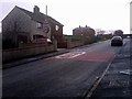
Hayfield Lane, Lerwick
At the top of the lane is Hayfield House, formerly a 'country' house outside the Lerwick burgh, but currently housing the Education Department of Shetland Islands Council.
Image: © Mike Pennington
Taken: 10 Nov 2009
0.12 miles
9
Lochside Stores, Lerwick
How this small general shop has survived, within sight of Lerwick's main supermarket (currently owned by Tesco), is something of a mystery to me.
Image: © Mike Pennington
Taken: 10 Nov 2009
0.12 miles
10
Lerwick Health Centre
Conveniently opposite the hospital.
Image: © Mike Pennington
Taken: 19 Oct 2016
0.13 miles