IMAGES TAKEN NEAR TO
Sletts Park, SHETLAND, ZE1 0LN
Introduction
This page details the photographs taken nearby to Sletts Park, ZE1 0LN by members of the Geograph project.
The Geograph project started in 2005 with the aim of publishing, organising and preserving representative images for every square kilometre of Great Britain, Ireland and the Isle of Man.

There are currently over 7.5m images from over14,400 individuals and you can help contribute to the project by visiting https://www.geograph.org.uk
Image Map (Loading...)


Getting Data...Please wait
Leaflet Map data © OpenStreetMap
Images are licensed for reuse under creativecommons.org/licenses/by-sa/2.0
Notes
- Clicking on the map will re-center to the selected point.
- The higher the marker number, the further away the image location is from the centre of the postcode.
Image Listing (150 Images Found)
Images are licensed for reuse under creativecommons.org/licenses/by-sa/2.0
Image
Details
Distance
3
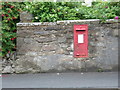
Lerwick: postbox № ZE1 52, Scalloway Road
This George V-reign postbox is set into the perimeter wall of 16 Scalloway Road. Like all postboxes in Lerwick, there are two weekday 'final collection' times, one for off-islands next-day delivery (11:30am) and one for Shetland items (5:15pm). The single advertised Saturday collection is 3:15pm.
Image: © Chris Downer
Taken: 2 Aug 2011
0.05 miles
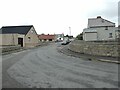
4
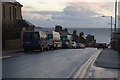
Burgh Road, Lerwick
Burgh Road was named because it was originally the boundary of the Lerwick burgh. The view is to the south and the Bressay lighthouse can be seen in the distance.
Image: © Mike Pennington
Taken: 30 Nov 2009
0.07 miles
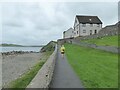
5

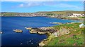
Brei Wick
Rocky shore on the south side of Lerwick. The houses of breiwick Road are in the background.
Image: © Colin Smith
Taken: 10 Jul 2010
0.07 miles
6
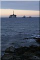
Beach at the Sletts
The drilling rig offshore is a relatively rare sight in Shetland these days.
Image: © Mike Pennington
Taken: 2 Oct 2007
0.07 miles
7

Breiwick Road
Grey stone houses with white corner stones overlooking the bay, Brei Wick, in Lerwick.
Image: © Colin Smith
Taken: 10 Jul 2010
0.08 miles
8
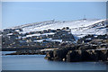
The Sletts, Lerwick
The coastline in the foreground is the Sletts. Beyond Sound is the Hill of Shurton.
Image: © Mike Pennington
Taken: 3 Mar 2010
0.08 miles
9
Looking over Brei Wick to the Gilbert Bain Hospital
The hospital is the large square building on the far right. Brei Wick is the bay to the south of Lerwick.
Image: © Gordon Brown
Taken: 5 Jun 2018
0.08 miles