IMAGES TAKEN NEAR TO
Haldane Burgess Crescent, SHETLAND, ZE1 0HR
Introduction
This page details the photographs taken nearby to Haldane Burgess Crescent, ZE1 0HR by members of the Geograph project.
The Geograph project started in 2005 with the aim of publishing, organising and preserving representative images for every square kilometre of Great Britain, Ireland and the Isle of Man.

There are currently over 7.5m images from over14,400 individuals and you can help contribute to the project by visiting https://www.geograph.org.uk
Image Map (Loading...)


Getting Data...Please wait
Leaflet Map data © OpenStreetMap
Images are licensed for reuse under creativecommons.org/licenses/by-sa/2.0
Notes
- Clicking on the map will re-center to the selected point.
- The higher the marker number, the further away the image location is from the centre of the postcode.
Image Listing (86 Images Found)
Images are licensed for reuse under creativecommons.org/licenses/by-sa/2.0
Image
Details
Distance
1

Phonebox and postbox, Anderson Road, Lerwick
Image: © Mike Pennington
Taken: 16 Apr 2011
0.03 miles
2
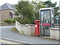
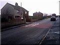
Lerwick: postbox № ZE1 62 and phone, Anderson Road
A George VI-reign postbox and modern telephone box in this residential area of the town. Like all boxes in Lerwick, there are two weekday 'final collection' times, one for off-islands next-day delivery (11:30am) and one for Shetland items (5:15pm). The single advertised Saturday collection is 10:15am.
Image: © Chris Downer
Taken: 3 Aug 2011
0.04 miles
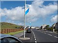
3

Looking down Gilbertson Road, Lerwick
Looking towards the Northlink ferry at the Holmsgarth terminal.
Image: © Mike Pennington
Taken: 16 Apr 2011
0.08 miles
4
South Lochside Road, Lerwick
Looking east along South Lochside Road, Lerwick. The pennats were attached to the lampposts during the NatWest Island Games, held across Shetland from 9-15 July 2005.
Image: © John Dally
Taken: 7 Jul 2005
0.10 miles
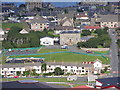
6
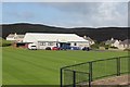
Running track at Clickimin, Lerwick
Hayfield House, currently housing the Education service, is the old house on the hill.
Image: © Mike Pennington
Taken: 19 Jun 2010
0.12 miles
8
Hayfield Lane, Lerwick
At the top of the lane is Hayfield House, formerly a 'country' house outside the Lerwick burgh, but currently housing the Education Department of Shetland Islands Council.
Image: © Mike Pennington
Taken: 10 Nov 2009
0.13 miles
9
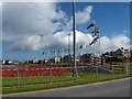
Running Track, Clickimin Leisure Centre, Lerwick
The Running Track at Clickimin Leisure Centre with flags flying for the NatWest Island Games which were held from 5-15 July 2005. In the background are the houses of South Lochside, Lerwick
Image: © John Dally
Taken: 7 Jul 2005
0.14 miles
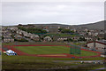
10
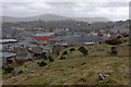
Lerwick from North Staney Hill
Skipidock is just visible on the left, with the bright red of the Toll Clock Shopping Centre just left of centre. The coastguard building on the Knab is on the horizon on the far right. Bressay is in the background. For a similar view from early in the 20th century see http://photos.shetland-museum.org.uk/image.php?i=35686&r=2&t=4&x=1.
Image: © Mike Pennington
Taken: 16 Apr 2011
0.14 miles