IMAGES TAKEN NEAR TO
Beaumont Place, SELBY, YO8 9EW
Introduction
This page details the photographs taken nearby to Beaumont Place, YO8 9EW by members of the Geograph project.
The Geograph project started in 2005 with the aim of publishing, organising and preserving representative images for every square kilometre of Great Britain, Ireland and the Isle of Man.

There are currently over 7.5m images from over14,400 individuals and you can help contribute to the project by visiting https://www.geograph.org.uk
Image Map
Images are licensed for reuse under creativecommons.org/licenses/by-sa/2.0
Notes
- Clicking on the map will re-center to the selected point.
- The higher the marker number, the further away the image location is from the centre of the postcode.
Image Listing (43 Images Found)
Images are licensed for reuse under creativecommons.org/licenses/by-sa/2.0
Image
Details
Distance

3
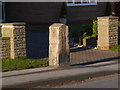
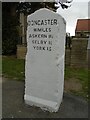
Milestone on the A19 Doncaster Road, Brayton
Erected by the Doncaster and Selby turnpike trust in the 19th century. Listed Grade II. See http://www.geograph.org.uk/photo/3794273 for more details. There is a bench mark incised into the right hand face http://www.geograph.org.uk/photo/3794274.
Image: © Alan Murray-Rust
Taken: 24 Dec 2013
0.07 miles
4
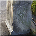
Bench mark on Brayton milestone
See http://www.geograph.org.uk/photo/3794272 for location.
Image: © Alan Murray-Rust
Taken: 24 Dec 2013
0.07 miles
5
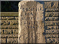
Old milestone
The turnpike from Doncaster to Selby was one of the last to be enacted in Yorkshire in 1832. 13 milestones on this route can still be found although 3 are in ditches. The most northerly stone in Brayton was knocked over in 2019 being reset in 2020. Later it was cleaned and painted by Milestone Society members. At some time in its history the mileage to York has been changed. It should read YORK 16. It is Grade II listed 1365809.
Image: © Chris Minto
Taken: 30 Aug 2021
0.08 miles
6
Milestone on the A19 Doncaster Road, Brayton - detail
See http://www.geograph.org.uk/photo/3794272 for the location. The sun was just at the right angle to highlight the inscription. Listed Grade II. Comparing the mileages with the similar milestone at Haigh End http://www.geograph.org.uk/photo/3794218 , the distance between Doncaster and York has decreased from 34 to 33!
Image: © Alan Murray-Rust
Taken: 24 Dec 2013
0.08 miles
7
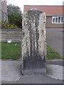
Old Milestone by the A19, Doncaster Road, Brayton
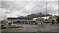
Carved stone post by the A19, in parish of BRAYTON (SELBY District), Brayton, Doncaster Road, on path outside Stonelea and near Tesco Extra Petrol Station, on West side of road. Askern stone, erected by the Doncaster & Selby (new Trust) turnpike trust in the 19th century.
Inscription reads:-
DONCASTER
1(8)½ MILES
ASKERN 11½
SELBY 1½
YORK 16
Carved benchmark on lower left face.
Grade II Listed. List Entry Number: 1365809
https://historicengland.org.uk/listing/the-list/list-entry/1365809
Milestone Society National ID: YN_DNSY18.
Image: © C Minto
Taken: 1 Mar 1993
0.08 miles
8
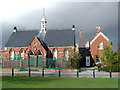
The Old School, Brayton
Brayton School (now Brayton Church of England Infant School) with the School House on the right, which were both built on the village green in 1872.
Image: © Paul Glazzard
Taken: 5 Apr 2008
0.09 miles
9
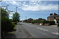
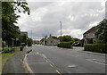
Doncaster Road from Meadow Croft
Looking along part of the A19, Doncaster Road, from Meadow Croft in Brayton.
Image: © DS Pugh
Taken: 13 May 2018
0.10 miles