IMAGES TAKEN NEAR TO
Park Road, SELBY, YO8 8EN
Introduction
This page details the photographs taken nearby to Park Road, YO8 8EN by members of the Geograph project.
The Geograph project started in 2005 with the aim of publishing, organising and preserving representative images for every square kilometre of Great Britain, Ireland and the Isle of Man.

There are currently over 7.5m images from over14,400 individuals and you can help contribute to the project by visiting https://www.geograph.org.uk
Image Map
Images are licensed for reuse under creativecommons.org/licenses/by-sa/2.0
Notes
- Clicking on the map will re-center to the selected point.
- The higher the marker number, the further away the image location is from the centre of the postcode.
Image Listing (30 Images Found)
Images are licensed for reuse under creativecommons.org/licenses/by-sa/2.0
Image
Details
Distance
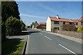
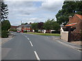
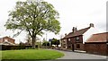
1
Park Road
Looking along Park Road from the junction with Brown Cow Road in Barlow.
Image: © DS Pugh
Taken: 20 Apr 2019
0.02 miles
2
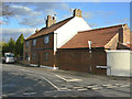
House on Brown Cow Road
The decorative brickwork is modern applied panelling. The road takes its name from the former riverside inn at the far end of the road.
Image: © Alan Murray-Rust
Taken: 26 Dec 2011
0.03 miles
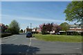
7
Park Road, Barlow
At corner with Brown Cow Road
Image: © Chris Morgan
Taken: 24 Apr 2018
0.06 miles
8
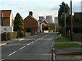
Park Lane, Barlow
Looking south-east from the junction with Brown Cow Road, with cooling towers of Drax Power Station Image in the background.
Image: © Alan Murray-Rust
Taken: 26 Dec 2011
0.07 miles