IMAGES TAKEN NEAR TO
Bank Road, SELBY, YO8 5AN
Introduction
This page details the photographs taken nearby to Bank Road, YO8 5AN by members of the Geograph project.
The Geograph project started in 2005 with the aim of publishing, organising and preserving representative images for every square kilometre of Great Britain, Ireland and the Isle of Man.

There are currently over 7.5m images from over14,400 individuals and you can help contribute to the project by visiting https://www.geograph.org.uk
Image Map
Images are licensed for reuse under creativecommons.org/licenses/by-sa/2.0
Notes
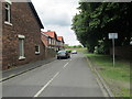
- Clicking on the map will re-center to the selected point.
- The higher the marker number, the further away the image location is from the centre of the postcode.
Image Listing (251 Images Found)
Images are licensed for reuse under creativecommons.org/licenses/by-sa/2.0
Image
Details
Distance
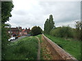
1
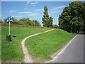
Access to embankment path
This path runs along the river bank towards Barlby.
Image: © DS Pugh
Taken: 22 Jul 2012
0.02 miles
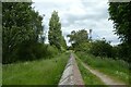
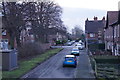
2
Above Bank Road
Looking along Bank Road from the path along the banks of the Ouse.
Image: © DS Pugh
Taken: 13 Jun 2021
0.02 miles
3
Bank Road, Selby
Showing position of Postbox No. YO8 16.
See Image] for postbox.
Image: © JThomas
Taken: 1 Feb 2020
0.02 miles
4
Flood wall beside the Ouse
Looking along the path beside the River Ouse.
Image: © DS Pugh
Taken: 13 Jun 2021
0.02 miles
8
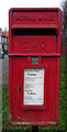
Elizabeth II postbox on Barlby Road, Selby
Image: © JThomas
Taken: 1 Feb 2020
0.03 miles
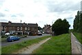
9
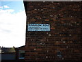
It is Bungalow Road, Selby
Google says this road is Bank Road.
Image: © Ian S
Taken: 6 Nov 2010
0.03 miles
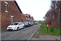
10
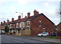
Houses on Barlby Road, Selby
Showing position of Postbox No. YO8 16.
See Image] for postbox.
Image: © JThomas
Taken: 1 Feb 2020
0.03 miles