IMAGES TAKEN NEAR TO
YO7 4YQ
Introduction
This page details the photographs taken nearby to YO7 4YQ by members of the Geograph project.
The Geograph project started in 2005 with the aim of publishing, organising and preserving representative images for every square kilometre of Great Britain, Ireland and the Isle of Man.

There are currently over 7.5m images from over14,400 individuals and you can help contribute to the project by visiting https://www.geograph.org.uk
Image Map
Images are licensed for reuse under creativecommons.org/licenses/by-sa/2.0
Notes
- Clicking on the map will re-center to the selected point.
- The higher the marker number, the further away the image location is from the centre of the postcode.
Image Listing (1 Images Found)
Images are licensed for reuse under creativecommons.org/licenses/by-sa/2.0
Image
Details
Distance
1
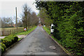
Access Drive to Breckenbrough Hall School
Access drive leading to the school from the A167 Northallerton/Topcliffe Road.
This Quaker Foundation establishment provides residential education for above ability boys who suffer from learning and behavioural difficulties.
Image: © Chris Heaton
Taken: 14 Apr 2016
0.19 miles