IMAGES TAKEN NEAR TO
Church View, Cemetery Road, THIRSK, YO7 4DL
Introduction
This page details the photographs taken nearby to Church View, Cemetery Road, YO7 4DL by members of the Geograph project.
The Geograph project started in 2005 with the aim of publishing, organising and preserving representative images for every square kilometre of Great Britain, Ireland and the Isle of Man.

There are currently over 7.5m images from over14,400 individuals and you can help contribute to the project by visiting https://www.geograph.org.uk
Image Map
Images are licensed for reuse under creativecommons.org/licenses/by-sa/2.0
Notes
- Clicking on the map will re-center to the selected point.
- The higher the marker number, the further away the image location is from the centre of the postcode.
Image Listing (100 Images Found)
Images are licensed for reuse under creativecommons.org/licenses/by-sa/2.0
Image
Details
Distance
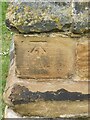
1
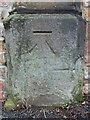
Benchmark on Thirsk Cemetery entrance
This Ordnance Survey benchmark is on the west side of the cemetery entrance, Cemetery Road, Thirsk. Levelled at 36.542m above Newlyn Datum verified 1975.
Image: © John S Turner
Taken: 29 Sep 2019
0.03 miles
2

Entrance to the cemetery, Cemetery Road, Thirsk
There is an Ordnance Survey benchmark on the stone post to the west of the entrance. Image
Image: © John S Turner
Taken: 29 Sep 2019
0.03 miles
4
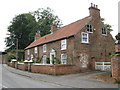
Thirsk Hall Cottages, 1 & 2 Cemetery Road
Grade 2 Listed C18 & C19 Cottages. See http://www.heritagegateway.org.uk/Gateway/Results_Single.aspx?uid=1314930&resourceID=5
Image: © Stephen Armstrong
Taken: 6 Jun 2011
0.10 miles
5
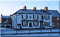
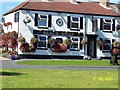
The Black Swan, Norby
Local pub noted for its floral displays in summer, but looking more like a place to warm up on a very cold December afternoon.
Image: © Gordon Hatton
Taken: 24 Dec 2010
0.11 miles
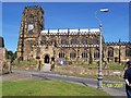
7
Church at Thirsk
At the Southern end of Northallerton Road.
Image: © Colin Grice
Taken: 12 May 2006
0.12 miles
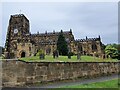
8
Ordnance Survey Bench Mark
This mark is located on the Parish Church of Thirsk, North Yorkshire. These marks were used by Ordnance Survey for mapping purposes.
Image
Image: © V1ncenze
Taken: 14 Jun 2021
0.12 miles
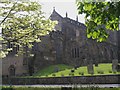
9
Thirsk Parish Church, North Yorkshire
The parish Church of Thirsk, North Yorkshire. This Church also has an Ordnance Survey bench mark.
Image
Image: © V1ncenze
Taken: 14 Jun 2021
0.12 miles
10
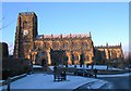
Parish church of St Mary
The large and impressive parish church in Thirsk is dedicated to Sain Mary and is reckoned to be the finest church of the Perpendicular period in North Yorkshire. It was begun about 1430 and work continued for around a century.
Image: © Gordon Hatton
Taken: 24 Dec 2010
0.12 miles