IMAGES TAKEN NEAR TO
Woodland Way, THIRSK, YO7 3SX
Introduction
This page details the photographs taken nearby to Woodland Way, YO7 3SX by members of the Geograph project.
The Geograph project started in 2005 with the aim of publishing, organising and preserving representative images for every square kilometre of Great Britain, Ireland and the Isle of Man.

There are currently over 7.5m images from over14,400 individuals and you can help contribute to the project by visiting https://www.geograph.org.uk
Image Map
Images are licensed for reuse under creativecommons.org/licenses/by-sa/2.0
Notes
- Clicking on the map will re-center to the selected point.
- The higher the marker number, the further away the image location is from the centre of the postcode.
Image Listing (12 Images Found)
Images are licensed for reuse under creativecommons.org/licenses/by-sa/2.0
Image
Details
Distance
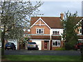
2

New housing development, Sowerby
Areas to either side of Topcliffe Road in Sowerby on the edge of Thirsk are undergoing extensive housing and commercial development. On the west side of the road is a rapidly growing housing estate full of uninspiring designs, and many with 'slate' roofing in an area which traditionally has pantiled roofs.
Image: © Gordon Hatton
Taken: 27 Jul 2016
0.15 miles

4
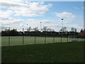
Sports pitches at Thirsk Comprehensive School
All weather pitches with floodlights.
Image: © Gordon Hatton
Taken: 10 Apr 2007
0.18 miles
5

An 'Exquisite development'
This new housing in Sowerby on the SE fringe of Thirsk is described thus on the advertising hoardings that line the roadside. Just a few months ago this area was green fields on the edge of a small market town, but now this huge apartment block has appeared together with some small bungalows which are dwarfed by comparison. Topcliffe Road has been re-aligned with two new roundabouts, but the old oak tree has been spared, although it is now so close to the roadway that one wonders if its roots have been damaged, whilst it seems only a matter of time before a vehicle runs off the road and collides with it.
Image: © Gordon Hatton
Taken: 27 Jul 2016
0.18 miles
6
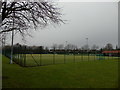
Astro Pitch at Thirsk School and Sixth Form College
Astro Pitch that serves as the home venue for Thirsk + Malton Mens Hockey Club, which field 3 sides.
Also for Thirsk Ladies Hockey Club that field an impressive 4 sides, and Northallerton Ladies Hockey Club that field 2 sides.
Image: © Chris Heaton
Taken: 11 Jan 2018
0.21 miles
7
Edge of Housing Estate in Sowerby, Thirsk
Image: © Chris Heaton
Taken: 11 Jan 2018
0.21 miles
8

Cheek by jowl
Part of the extensive new housing development off Topcliffe Road on the edge of Thirsk. The houses seem incredibly close together, but doubtless that has something to do with building regulations these days and the number of dwellings that must be built in each hectare.
Image: © Gordon Hatton
Taken: 6 Mar 2017
0.21 miles
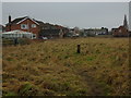
9
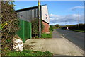
Sowerby Milepost
Beside the B1448 Topcliffe Road; 1 mile to Thirsk and 10 miles from Borobridge.
Image: © David Rogers
Taken: 2 Nov 2009
0.23 miles
10
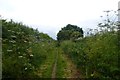
Track to Thirsk
A green lane running into Thirsk.
Image: © DS Pugh
Taken: 15 Jun 2014
0.24 miles