IMAGES TAKEN NEAR TO
Swale View, THIRSK, YO7 3RN
Introduction
This page details the photographs taken nearby to Swale View, YO7 3RN by members of the Geograph project.
The Geograph project started in 2005 with the aim of publishing, organising and preserving representative images for every square kilometre of Great Britain, Ireland and the Isle of Man.

There are currently over 7.5m images from over14,400 individuals and you can help contribute to the project by visiting https://www.geograph.org.uk
Image Map
Images are licensed for reuse under creativecommons.org/licenses/by-sa/2.0
Notes
- Clicking on the map will re-center to the selected point.
- The higher the marker number, the further away the image location is from the centre of the postcode.
Image Listing (93 Images Found)
Images are licensed for reuse under creativecommons.org/licenses/by-sa/2.0
Image
Details
Distance
1
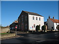
Methodist chapel Topcliffe
The Methodist chapel dates from 1840.
Update 2023. After years of declining attendances, the chapel eventually closed [circa 2020] and has since been converted into a private house.
Image: © Gordon Hatton
Taken: 30 Jan 2007
0.02 miles
2
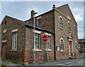
Topcliffe, Methodist church
A wider angle showing the Methodist church which is on the east side of Church Street. The parish church is directly opposite the Methodist church. On the far left of this west facing wall is a damaged benchmark. On the 4th row of bricks at the extreme left of the building, is a cut mark, which is very clear together with the top part of the arrowhead. The lower bricks have been removed and so part of the benchmark is missing.
Image: © Mel Towler
Taken: 31 Jul 2021
0.03 miles
3
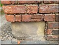
Topcliffe, Methodist church
The Methodist church is on the east side of Church Street. The parish church is directly opposite the Methodist church. On the far left of the west facing wall is a damaged benchmark. On the 4th row of bricks at the extreme left of the building, is a cut mark, which is very clear together with the top part of the arrowhead. The lower bricks have been removed and so part of the benchmark is missing.
Image: © Mel Towler
Taken: 31 Jul 2021
0.03 miles
4
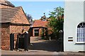
The Stables
The Stables is at Long Street in Topcliffe.
Image: © David Rogers
Taken: 2 Jul 2008
0.03 miles
5
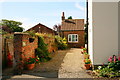
Honeypot Cottage
Honeypot Cottage is set back from Long Street at Topcliffe.
Image: © David Rogers
Taken: 2 Jul 2008
0.03 miles
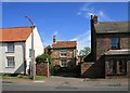
6

Wide Steps
On the corner of Long Street and Front Street at Topcliffe.
Image: © David Rogers
Taken: 2 Jul 2008
0.03 miles
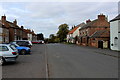
7
Road Junction
Looking from The Angel Inn across Long Street to the junction with Front Street.
Image: © David Rogers
Taken: 2 Jul 2008
0.03 miles
8
The Cotter's House
Set back on Long Street is The Cotter's House at Topcliffe.
Image: © David Rogers
Taken: 2 Jul 2008
0.03 miles
9
Topcliffe
Centre of this little village, above the banks of the Lower Swale
Image: © Chris Heaton
Taken: 20 Oct 2015
0.04 miles
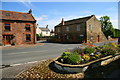
10
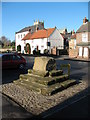
Market Cross Topcliffe
The village cross is most probably medieval, but little else is known about it. A fair was established in 1327 and the last one took place in 1969. Nobody knows if the cross ever had a shaft and cross head.
Image: © Gordon Hatton
Taken: 30 Jan 2007
0.04 miles