IMAGES TAKEN NEAR TO
Back Lane, THIRSK, YO7 3QB
Introduction
This page details the photographs taken nearby to Back Lane, YO7 3QB by members of the Geograph project.
The Geograph project started in 2005 with the aim of publishing, organising and preserving representative images for every square kilometre of Great Britain, Ireland and the Isle of Man.

There are currently over 7.5m images from over14,400 individuals and you can help contribute to the project by visiting https://www.geograph.org.uk
Image Map (Loading...)


Getting Data...Please wait
Leaflet Map data © OpenStreetMap
Images are licensed for reuse under creativecommons.org/licenses/by-sa/2.0
Notes
- Clicking on the map will re-center to the selected point.
- The higher the marker number, the further away the image location is from the centre of the postcode.
Image Listing (48 Images Found)
Images are licensed for reuse under creativecommons.org/licenses/by-sa/2.0
Image
Details
Distance
3
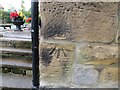
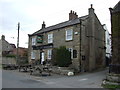
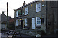
Ordnance Survey Cut Mark
This mark can be found on the wall of The Bay Horse PH in Rainton. The benchmark has been calculated as being 35.196 metres above sea level and was first used in 1908.
For more detail see : https://www.bench-marks.org.uk/bm49486
Image: © Peter Wood
Taken: 3 Aug 2018
0.05 miles

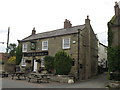
5
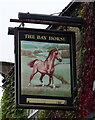
The Bay Horse Inn, Rainton
Village pub with bed and breakfast accommodation convenient for the A1.
Image: © Stephen McKay
Taken: 3 Apr 2015
0.05 miles