IMAGES TAKEN NEAR TO
Sessay, THIRSK, YO7 3NF
Introduction
This page details the photographs taken nearby to YO7 3NF by members of the Geograph project.
The Geograph project started in 2005 with the aim of publishing, organising and preserving representative images for every square kilometre of Great Britain, Ireland and the Isle of Man.

There are currently over 7.5m images from over14,400 individuals and you can help contribute to the project by visiting https://www.geograph.org.uk
Image Map
Images are licensed for reuse under creativecommons.org/licenses/by-sa/2.0
Notes
- Clicking on the map will re-center to the selected point.
- The higher the marker number, the further away the image location is from the centre of the postcode.
Image Listing (1 Images Found)
Images are licensed for reuse under creativecommons.org/licenses/by-sa/2.0
Image
Details
Distance
1
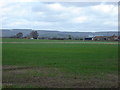
Briar Hill Farm and the White Horse
High on the hill to the left can be seen the White Horse above the village of Kilburn. This flat area is the Vale of York, the hills being the edge of the North York Moors at Sutton Bank
Image: © Martin Dawes
Taken: 8 Apr 2009
0.05 miles