IMAGES TAKEN NEAR TO
Thorpefield, THIRSK, YO7 3HJ
Introduction
This page details the photographs taken nearby to YO7 3HJ by members of the Geograph project.
The Geograph project started in 2005 with the aim of publishing, organising and preserving representative images for every square kilometre of Great Britain, Ireland and the Isle of Man.

There are currently over 7.5m images from over14,400 individuals and you can help contribute to the project by visiting https://www.geograph.org.uk
Image Map
Images are licensed for reuse under creativecommons.org/licenses/by-sa/2.0
Notes
- Clicking on the map will re-center to the selected point.
- The higher the marker number, the further away the image location is from the centre of the postcode.
Image Listing (13 Images Found)
Images are licensed for reuse under creativecommons.org/licenses/by-sa/2.0
Image
Details
Distance
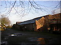
1
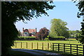
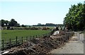
Hagg House
Surrounded by pastures, which are in turn encircled by the B1448 from Thirsk to the east, the busy dual carriageway A168 to the south and Topcliffe Airfield to the west.
Image: © Chris Heaton
Taken: 30 May 2021
0.03 miles
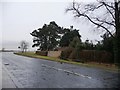
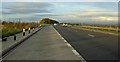
2
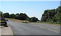
Changes coming soon
A view of the slip roads at the point where the B1448 out of Thirsk joins the A168 dual carriageway. Since the A168 was constructed in the 1970's this has been a restricted junction with access northbound from A168 into Thirsk and southbound from Thirsk on to A168, but there has never been access to the northbound carriageway or from that heading south. This is to change over the coming months and the road will be closed from 7th July 2018 and may remain so for many months as extensive [and expensive] roadworks take place.
Image: © Gordon Hatton
Taken: 29 Jun 2018
0.10 miles
3
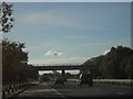
A168 Road Bridge
Road Bridge carrying the B1448 over the A168 near Thorpefield.
Image: © Darren Haddock
Taken: 24 Oct 2006
0.11 miles
4
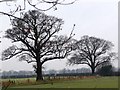
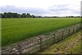
Winter trees, Thorpefield
Along a field boundary near Warren House.
Image: © Christine Johnstone
Taken: 10 Jan 2011
0.15 miles
5
The work begins
As can be seen from the map extract for this square [and 3 adjacent], the B1448 junction with the A168 dual carriageway has always been restricted to a northbound exit from A168 and a southbound access from the B1448 out of Thirsk. From July 7th 2018 the junction will be closed as work begins to make this a full access junction. Work has begun already with extensive tree clearance and initial ground work on the north side of the overbridge.
Image: © Gordon Hatton
Taken: 29 Jun 2018
0.15 miles
6
Topcliffe Road
The B1448 bending round Thorpefield Farm.
Image: © Christine Johnstone
Taken: 10 Jan 2011
0.18 miles
8
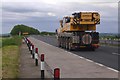
Crane on the A168
Northbound, Ox Moor.
Image: © Richard Webb
Taken: 22 May 2016
0.20 miles
10
New Thropefield Farm
Farm building with OS Flush Bracket 11565 mounted on wall behind 'mushroom' planter
Image: © manonabike
Taken: 7 Dec 2006
0.22 miles