IMAGES TAKEN NEAR TO
Greenfield Close, THIRSK, YO7 3FS
Introduction
This page details the photographs taken nearby to Greenfield Close, YO7 3FS by members of the Geograph project.
The Geograph project started in 2005 with the aim of publishing, organising and preserving representative images for every square kilometre of Great Britain, Ireland and the Isle of Man.

There are currently over 7.5m images from over14,400 individuals and you can help contribute to the project by visiting https://www.geograph.org.uk
Image Map
Images are licensed for reuse under creativecommons.org/licenses/by-sa/2.0
Notes
- Clicking on the map will re-center to the selected point.
- The higher the marker number, the further away the image location is from the centre of the postcode.
Image Listing (53 Images Found)
Images are licensed for reuse under creativecommons.org/licenses/by-sa/2.0
Image
Details
Distance
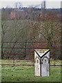
1

Village school Topcliffe
Typical 1970's school building that replaced a much older building situated behind the post office.
Image: © Gordon Hatton
Taken: 30 Jan 2007
0.03 miles
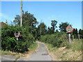
2
Topcliffe Milepost
beside the A167 just north of the village. Topcliffe Mill, on the banks of the River Swale, is beyond the trees.
Image: © David Rogers
Taken: 6 Jan 2011
0.05 miles
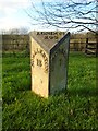
3

Old Milestone, on the A167, N end of village
100m S of Kibber Hill. Located on the West side of road, on grass verge. Cast iron post, Northallerton casting design, 19th century. Alternative views see http://www.geograph.org.uk/photo/6687052 & http://www.geograph.org.uk/photo/2253238 & http://www.geograph.org.uk/photo/138125
Inscription reads: NO'ALLERTON / 12 // BORO'BRIDGE / 7 // LONDON / 209
Grade II listed by Historic England.
Milestone Society National ID: YN_NABB12
Image: © Christine Minto
Taken: 21 Dec 2005
0.06 miles
4
Old milepost
Surveyed by the Milestone Society. At the north end of Topcliffe on the west side verge. This is one of several remaining mileposts of the same design from Boroughbridge, through Northallerton and towards the county boundary with County Durham at High Entercommon. It is not known at which foundry they were cast. This post is Grade II listed 332611.
Image: © Chris Minto
Taken: 22 Nov 2020
0.06 miles
5
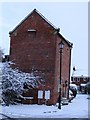
The dovecot, Topcliffe
Now standing amongst a small nineties housing development, this late 18th century brick dovecot was once part of Hall Farm. It stood disused for many years, but when the residential development took place around it, the dovecot was converted into a single bedroom house, with some restrictions as to where new windows could be inserted.
Image: © Gordon Hatton
Taken: 18 Dec 2009
0.10 miles
6
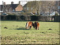
Shetland Ponies Topcliffe
A tall hedge, or small horses? The latter is correct as a local breeder keeps some very small Shetlands [and some normal sized llamas].
Image: © Gordon Hatton
Taken: 30 Jan 2007
0.11 miles

8
Back Lane, Topcliffe
Back Lane joins Long Street with the road to Busby Stoop and probably marks the end of former 'toft and croft' lands, where the original dwellings along what is now Front Street would have had long strips of land to the rear where small amounts of food could be grown or a few animals kept.
Image: © Gordon Hatton
Taken: 1 Jul 2018
0.13 miles
9

Flood conditions at the Sheepwash
A very similar scene to one I photographed in March 2019. Comparing the two photos, I think the water is marginally higher on this occasion.
Image: © Gordon Hatton
Taken: 3 Nov 2020
0.14 miles
10

Even higher at the Sheepwash
This appears to be a popular subject for me as there are several pictures on the website of high water at this point. However, this one shows the water level even higher than on previous occasions, such as on November 3rd 2020 and 17th March 2019.
Image: © Gordon Hatton
Taken: 21 Jan 2021
0.14 miles