IMAGES TAKEN NEAR TO
Islebeck Road, THIRSK, YO7 3AG
Introduction
This page details the photographs taken nearby to Islebeck Road, YO7 3AG by members of the Geograph project.
The Geograph project started in 2005 with the aim of publishing, organising and preserving representative images for every square kilometre of Great Britain, Ireland and the Isle of Man.

There are currently over 7.5m images from over14,400 individuals and you can help contribute to the project by visiting https://www.geograph.org.uk
Image Map
Images are licensed for reuse under creativecommons.org/licenses/by-sa/2.0
Notes
- Clicking on the map will re-center to the selected point.
- The higher the marker number, the further away the image location is from the centre of the postcode.
Image Listing (8 Images Found)
Images are licensed for reuse under creativecommons.org/licenses/by-sa/2.0
Image
Details
Distance

2
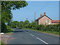
Moor End Lane
Moor End Lane at Moor End Farm on the road to Sowerby.
Image: © Gordon Hatton
Taken: 23 May 2010
0.02 miles

4
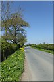
Road to Sowerby
Looking along Moor End Lane.
Image: © DS Pugh
Taken: 5 May 2018
0.14 miles
5
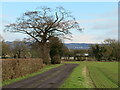
Track to Spring House
Track to Spring House farm off Moor End Lane. The farmhouse is roughly halfway between the lane and the A19 to the east.
Image: © Gordon Hatton
Taken: 18 Jan 2021
0.16 miles
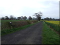
7
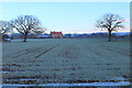
North Park Farm
Looking towards the farm on a cold and frosty morning
Image: © Chris Heaton
Taken: 30 Dec 2020
0.24 miles
8
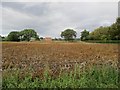
North Park Farm over potato field
The potatoes have been sprayed to kill the tops off prior to being lifted
Image: © Martin Dawes
Taken: 8 Sep 2017
0.24 miles