IMAGES TAKEN NEAR TO
Nether Silton, THIRSK, YO7 2LL
Introduction
This page details the photographs taken nearby to YO7 2LL by members of the Geograph project.
The Geograph project started in 2005 with the aim of publishing, organising and preserving representative images for every square kilometre of Great Britain, Ireland and the Isle of Man.

There are currently over 7.5m images from over14,400 individuals and you can help contribute to the project by visiting https://www.geograph.org.uk
Image Map
Images are licensed for reuse under creativecommons.org/licenses/by-sa/2.0
Notes
- Clicking on the map will re-center to the selected point.
- The higher the marker number, the further away the image location is from the centre of the postcode.
Image Listing (12 Images Found)
Images are licensed for reuse under creativecommons.org/licenses/by-sa/2.0
Image
Details
Distance
1
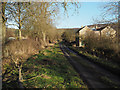
Moor House
A minor 'dead end' road passes Moor House heading for a car park in forestry plantations at the edge of the North Yorks Moors national park.
Image: © Trevor Littlewood
Taken: 19 Dec 2014
0.03 miles
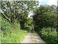
2
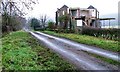
Moor Lane and Moor House
Moor House, situated on National Cycleway No. 65, is currently undergoing renovation.
Image: © Mick Garratt
Taken: 24 Dec 2006
0.03 miles
3
Hunter's Hill from Forestry
The track through the trees dips to the field wall at this point
Image: © Martin Dawes
Taken: 23 Mar 2010
0.16 miles
5
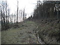
Forest Track on Knipes Hill
This is a very large patch of forestry, coming west from the bulk of Hambleton End down to the villages of Over Silton and Nether Silton
Image: © Martin Dawes
Taken: 23 Mar 2010
0.21 miles
6
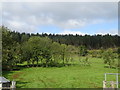
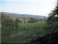
Grazing, Hunter's Hill
Towards woodland off Moor Lane.
Image: © JThomas
Taken: 19 Sep 2020
0.22 miles
7
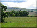
Public Footpath
View from a footpath off Moor Lane towards disused quarries on Kepwick Moor.
Image: © David Rogers
Taken: 23 Jun 2008
0.22 miles
8
Sheep beside Moor Lane
The soggy sheep are in a very narrow field between woods and the road.
Image: © Richard Webb
Taken: 11 Aug 2016
0.23 miles
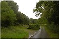
9
Moor Lane
National Cycle Route 65 becoming more of a track before it reaches Silton Forest.
Image: © JThomas
Taken: 19 Sep 2020
0.24 miles
10
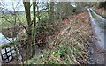
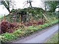
Nether Silton, Sorrow Beck
According to the OS benchmark database there is a benchmark cut into the centre of the bridge on the east side of the road. There is no bridge and considerable amount of vegetation needs to be cleared to find the cutmark.
Image: © Mel Towler
Taken: 5 Jan 2023
0.24 miles