IMAGES TAKEN NEAR TO
Kepwick, THIRSK, YO7 2JR
Introduction
This page details the photographs taken nearby to YO7 2JR by members of the Geograph project.
The Geograph project started in 2005 with the aim of publishing, organising and preserving representative images for every square kilometre of Great Britain, Ireland and the Isle of Man.

There are currently over 7.5m images from over14,400 individuals and you can help contribute to the project by visiting https://www.geograph.org.uk
Image Map (15 Images)


Getting Data...Please wait
Leaflet Map data © OpenStreetMap
Images are licensed for reuse under creativecommons.org/licenses/by-sa/2.0
Notes
- Clicking on the map will re-center to the selected point.
- The higher the marker number, the further away the image location is from the centre of the postcode.
Image Listing (15 Images Found)
Images are licensed for reuse under creativecommons.org/licenses/by-sa/2.0
Image
Details
Distance
1
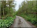
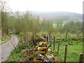
Kepwick, Rag Robin Turn
According to the OS benchmark database there is a benchmark cut into the wall opposite this track entrance on the left. The wall was quite tumbled and despite searching many stones nothing was found.
Image: © Mel Towler
Taken: 2 May 2022
0.04 miles
2
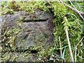
Kepwick, Rag Round Turn
The rivet/benchmark is in the roadside wall on the south side of the lane.
Image: © Mel Towler
Taken: 2 May 2022
0.06 miles
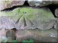
3
Kepwick, Rag Robin Turn
There is a rivet/benchmark cut into the roadside wall on the south side of the lane.
Image: © Mel Towler
Taken: 2 May 2022
0.06 miles
4
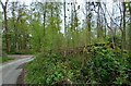
Kepwick, Rag Robin Turn
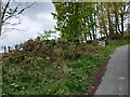
According to the OS benchmark database there is a benchmark cut into this stretch of roadside wall which is on the west of the lane. Too much vegetation, brambles and undergrowth to make an attempt for a search. The wall seemed intact and it is likely the cutmark will still be there.
Image: © Mel Towler
Taken: 2 May 2022
0.07 miles
5
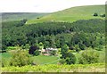
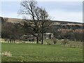
Looking down to Kepwick Hall
Kepwick Hall has a sheltered location below the western edge of the Hambleton Hills. The house is late 19th century in a neo-Tudor style.
Image: © Gordon Hatton
Taken: 19 Jun 2019
0.09 miles
7
Rag Robin Turn near Kepwick Hall
Rag Robin Turn on the hill east of Kepwick Hall.
Image: © T Eyre
Taken: 2 May 2012
0.10 miles
8
Kepwick, Rag Robin Turn
The benchmark is cut into the roadside wall on the west side of the lane.
Image: © Mel Towler
Taken: 2 May 2022
0.11 miles
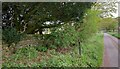
9
Kepwick, Rag Robin Turn
There is a benchmark cut into the roadside wall on the west side of the lane. Follow diagonally left from the top of the wooden post and the cleared stone in the wall can be seen.
Image: © Mel Towler
Taken: 2 May 2022
0.11 miles
10
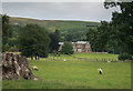
View to Kepwick Hall
Kepwick hall dates from 1873 and is Grade II listed. https://historicengland.org.uk/listing/the-list/list-entry/1150848?section=official-list-entry
Image: © David Robinson
Taken: 15 Mar 2022
0.11 miles