IMAGES TAKEN NEAR TO
Kirby Knowle, THIRSK, YO7 2JG
Introduction
This page details the photographs taken nearby to YO7 2JG by members of the Geograph project.
The Geograph project started in 2005 with the aim of publishing, organising and preserving representative images for every square kilometre of Great Britain, Ireland and the Isle of Man.

There are currently over 7.5m images from over14,400 individuals and you can help contribute to the project by visiting https://www.geograph.org.uk
Image Map
Images are licensed for reuse under creativecommons.org/licenses/by-sa/2.0
Notes
- Clicking on the map will re-center to the selected point.
- The higher the marker number, the further away the image location is from the centre of the postcode.
Image Listing (10 Images Found)
Images are licensed for reuse under creativecommons.org/licenses/by-sa/2.0
Image
Details
Distance
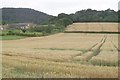
4
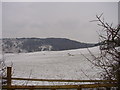
Wintry Farmland
Adjacent to Pallet Hill, looking east.
Image: © Bob Jenkins
Taken: 13 Mar 2006
0.08 miles
5
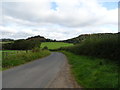
Bend in National Cycle Route 65
Towards Kirby Knowle.
Image: © JThomas
Taken: 19 Sep 2020
0.11 miles
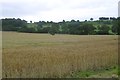
7
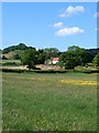
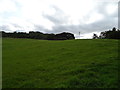
Meadow near Felixkirk
Meadowland north of Felixkirk, looking towards Lawn House. The hill in the distance on the left is Knowle Hill at Kirby Knowle.
Image: © Gordon Hatton
Taken: 12 Jun 2010
0.15 miles
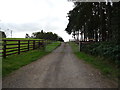
8
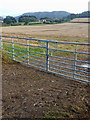
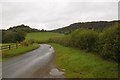
Double gate into field below Pallet Hill
Image: © Mick Garratt
Taken: 10 Sep 2019
0.18 miles