IMAGES TAKEN NEAR TO
Sutton, THIRSK, YO7 2EU
Introduction
This page details the photographs taken nearby to YO7 2EU by members of the Geograph project.
The Geograph project started in 2005 with the aim of publishing, organising and preserving representative images for every square kilometre of Great Britain, Ireland and the Isle of Man.

There are currently over 7.5m images from over14,400 individuals and you can help contribute to the project by visiting https://www.geograph.org.uk
Image Map (Loading...)


Getting Data...Please wait
Leaflet Map data © OpenStreetMap
Images are licensed for reuse under creativecommons.org/licenses/by-sa/2.0
Notes
- Clicking on the map will re-center to the selected point.
- The higher the marker number, the further away the image location is from the centre of the postcode.
Image Listing (21 Images Found)
Images are licensed for reuse under creativecommons.org/licenses/by-sa/2.0
Image
Details
Distance
1

Happy Valley
With the A170 running through the centre on its way to Thirsk.
Image: © Peter Jeffery
Taken: 21 May 2015
0.03 miles
2

Sutton Bank
Approaching Sutton Bank on the A170, 5 miles from Thirsk.
Image: © David Rogers
Taken: 4 Feb 2009
0.04 miles
3
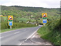
A quiet moment on the A170
The usually busy A170 climbs to the North Yorkshire Moors plateau by this route and it is very steep for an A road.
Caravans are banned and as the sign indicates, HGVs are likely to have problems especially at the hairpin bend halfway up.
Image: © Colin Grice
Taken: 14 May 2008
0.04 miles
4

Warning signs on the approach to Sutton Bank
The A170 climbs to the North Yorkshire Moors plateau by this route and it is very steep for an A road.
Caravans are banned and as the sign indicates, HGVs are likely to have problems especially at the hairpin bend halfway up.
Image: © Colin Grice
Taken: 14 May 2008
0.07 miles
5
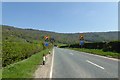
Signs warn of Sutton Bank
Approaching Sutton Bank on the A170 with its steep gradients. The Tour de Yorkshire will pass here shortly, including climbing the bank.
Image: © DS Pugh
Taken: 5 May 2018
0.08 miles
6
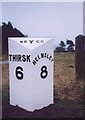
Old Milepost by the A170, west of Sutton Bank
Milepost by the A170, in parish of Sutton under Whitestonecliffe (Hambleton District), West of Sutton Bank, 225m West of track to Gormire Lake, on verge.
Inscription reads:-
: THIRSK / 6 : : NRYCC : : HELMSLEY / 8 :
Grade II listed.
List Entry Number: 1190943 https://historicengland.org.uk/listing/the-list/list-entry/1190943
Milestone Society National ID: YN_TKHM05
Image: © Milestone Society
Taken: Unknown
0.08 miles
7

25% Gradient
The A170 is closed for the Tour de France. Large numbers were walking or cycling to watch the riders pass.
Image: © DS Pugh
Taken: 5 May 2018
0.11 miles
8

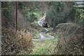
Track to Gormire Farm.
Heading for Gormire Lake.
Image: © steven ruffles
Taken: 18 Mar 2012
0.11 miles
9

A170 Sutton Bank ahead, up in the descending fog
Image: © Colin Pyle
Taken: 2 Nov 2015
0.12 miles