IMAGES TAKEN NEAR TO
Bagby, THIRSK, YO7 2AG
Introduction
This page details the photographs taken nearby to YO7 2AG by members of the Geograph project.
The Geograph project started in 2005 with the aim of publishing, organising and preserving representative images for every square kilometre of Great Britain, Ireland and the Isle of Man.

There are currently over 7.5m images from over14,400 individuals and you can help contribute to the project by visiting https://www.geograph.org.uk
Image Map
Images are licensed for reuse under creativecommons.org/licenses/by-sa/2.0
Notes
- Clicking on the map will re-center to the selected point.
- The higher the marker number, the further away the image location is from the centre of the postcode.
Image Listing (9 Images Found)
Images are licensed for reuse under creativecommons.org/licenses/by-sa/2.0
Image
Details
Distance
4
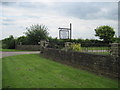
Cats Country Club Moor Lane Bagby
Not just a cattery
Image: © Martin Dawes
Taken: 13 Jun 2012
0.09 miles
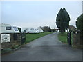
5
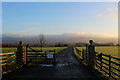
Access to Moor Park Farm
The establishment is a visitor attraction with farm animals to meet and other fun facilities to enjoy
Image: © Chris Heaton
Taken: 15 Dec 2020
0.09 miles
6
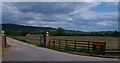
Monk Park Farm entrance
The entrance to Monk Park which is a visitor centre with attractions for families.
Image: © Gordon Hatton
Taken: 12 Jun 2010
0.10 miles
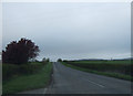
7
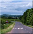
Moor Lane
Moor Lane links Bagby with the A170 for Thirsk. Looking north towards the distant outline of Wool Moor.
Image: © Gordon Hatton
Taken: 12 Jun 2010
0.14 miles
8
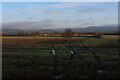
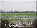
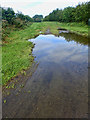
Balk Moor
Looking east from Moor Lane over the soggy fields of Balk Moor towards the distant North York Moors and Hambleton Hills
Image: © Chris Heaton
Taken: 15 Dec 2020
0.17 miles