IMAGES TAKEN NEAR TO
YO6 2JQ
Introduction
This page details the photographs taken nearby to YO6 2JQ by members of the Geograph project.
The Geograph project started in 2005 with the aim of publishing, organising and preserving representative images for every square kilometre of Great Britain, Ireland and the Isle of Man.

There are currently over 7.5m images from over14,400 individuals and you can help contribute to the project by visiting https://www.geograph.org.uk
Image Map
Images are licensed for reuse under creativecommons.org/licenses/by-sa/2.0
Notes
- Clicking on the map will re-center to the selected point.
- The higher the marker number, the further away the image location is from the centre of the postcode.
Image Listing (9 Images Found)
Images are licensed for reuse under creativecommons.org/licenses/by-sa/2.0
Image
Details
Distance
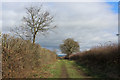
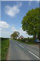
1
Road near White Horse Lodge
Looking along the road between Flawith and Tholthorpe.
Image: © DS Pugh
Taken: 15 Aug 2021
0.02 miles
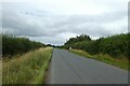
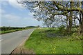
4
Road to Helperby
Leaving Flawith on the road to Brafferton/Helperby.
Image: © DS Pugh
Taken: 5 May 2018
0.11 miles
5
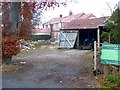
House at Flawith
Building work in progress.
Image: © Oliver Dixon
Taken: 16 Nov 2018
0.14 miles
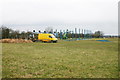
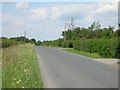
7
Road verge west of Flawith
The road leads towards Helperby.
Image: © DS Pugh
Taken: 5 May 2018
0.18 miles
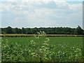
8
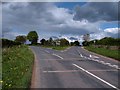
Fork in the road
Road junction at Flawith, with the road to Helperby to the left and that to Tholthorpe to the right.
Image: © Gordon Hatton
Taken: 12 May 2010
0.18 miles