IMAGES TAKEN NEAR TO
Shaw Drive, YORK, YO62 6PS
Introduction
This page details the photographs taken nearby to Shaw Drive, YO62 6PS by members of the Geograph project.
The Geograph project started in 2005 with the aim of publishing, organising and preserving representative images for every square kilometre of Great Britain, Ireland and the Isle of Man.

There are currently over 7.5m images from over14,400 individuals and you can help contribute to the project by visiting https://www.geograph.org.uk
Image Map
Images are licensed for reuse under creativecommons.org/licenses/by-sa/2.0
Notes
- Clicking on the map will re-center to the selected point.
- The higher the marker number, the further away the image location is from the centre of the postcode.
Image Listing (146 Images Found)
Images are licensed for reuse under creativecommons.org/licenses/by-sa/2.0
Image
Details
Distance
1
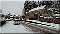
Start of Gillamoor Road
Looking uphill at the start of Gillamoor Road, Kirkbymoorside.
Image: © T Eyre
Taken: 29 Dec 2017
0.10 miles
2
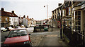
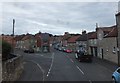
Kirkbymoorside Market Place
Looking south from the corner of Upper Market Place and Tinley Garth, down Market Place (the area is transformed on market day, Wednesday) to Piercy End, once Railway Street. Post Office on the right.
Image: © John Martin
Taken: 4 Feb 2007
0.12 miles
3
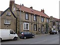
The King's Head, Upper Market Place, Kirkbymoorside
A sign reads: friendly food, delicious staff.
Image: © John Martin
Taken: 11 Mar 2007
0.12 miles
4
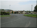
Entering West Pasture Kirkbymoorside
Walked a footpath over the fields it enters this residential street here
Image: © Martin Dawes
Taken: 24 Apr 2019
0.13 miles
5

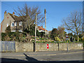
Low Hall at Kirkbymoorside
This substantial house is just beyond the Northern end of the main street.
It dates to the late 18th Century.
Image: © Colin Grice
Taken: 9 Nov 2007
0.13 miles
6
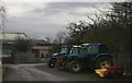
Russells yard at Kirkbymoorside
Agricultural machinery dealer occupying the former railway station and sidings at Kirkbymoorside - by the A170.
Image: © Colin Grice
Taken: 17 Jan 2005
0.13 miles
7
West end of Kirkbymoorside
Travelling towards the town centre. The road ahead is West End; to the left is Tinley Garth.
Image: © Barbara Carr
Taken: 16 Jun 2013
0.14 miles
8
Georgian postbox, Tinley Garth
By the junction with West End.
Image: © Pauline E
Taken: 3 Apr 2011
0.14 miles
9
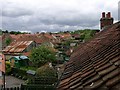
Gardens and roofs behind West End and Tinley Garth
Showing the older mix of buildings and the new roofs of Tinley Court to
the left. A traditional pan-tile roof is shown on the right.
Image: © Martin Smith
Taken: 21 May 2003
0.14 miles
10
No 83, West End
A grade II listed 1½-storey house from the early/mid C18, with earlier origins. Built in coursed rubble sandstone, partly cruck-framed, and with a single chimney stack to the left of a steeply-pitched pantile roof.
LBS No: 328432
Image: © Mike Kirby
Taken: 9 Jul 2011
0.15 miles