IMAGES TAKEN NEAR TO
Helmsley, YORK, YO62 5HH
Introduction
This page details the photographs taken nearby to YO62 5HH by members of the Geograph project.
The Geograph project started in 2005 with the aim of publishing, organising and preserving representative images for every square kilometre of Great Britain, Ireland and the Isle of Man.

There are currently over 7.5m images from over14,400 individuals and you can help contribute to the project by visiting https://www.geograph.org.uk
Image Map
Images are licensed for reuse under creativecommons.org/licenses/by-sa/2.0
Notes
- Clicking on the map will re-center to the selected point.
- The higher the marker number, the further away the image location is from the centre of the postcode.
Image Listing (8 Images Found)
Images are licensed for reuse under creativecommons.org/licenses/by-sa/2.0
Image
Details
Distance
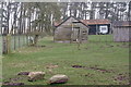
3

Lambs feeding on haybale
Lambs feeding on a haybale near Carlton Grange.
Image: © T Eyre
Taken: 17 Apr 2012
0.09 miles
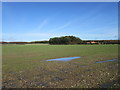
5
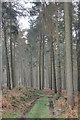
Ash Dale
A typical dry valley on the Tabular Hills. Ash Dale doesn't live up to its title at this point as larch and other conifers are the main species of tree.
Image: © Gordon Hatton
Taken: 10 Mar 2014
0.22 miles
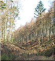
7
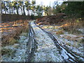
Snow in Ash Dale
Snow remains in the shade of the trees at the top of Ash Dale.
Image: © T Eyre
Taken: 30 Dec 2020
0.25 miles
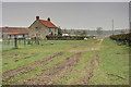
8
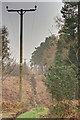
Electricity Transmission Poles, Ash Dale
Image: © Mick Garratt
Taken: 3 Apr 2014
0.25 miles