IMAGES TAKEN NEAR TO
Husthwaite, YORK, YO61 4PW
Introduction
This page details the photographs taken nearby to YO61 4PW by members of the Geograph project.
The Geograph project started in 2005 with the aim of publishing, organising and preserving representative images for every square kilometre of Great Britain, Ireland and the Isle of Man.

There are currently over 7.5m images from over14,400 individuals and you can help contribute to the project by visiting https://www.geograph.org.uk
Image Map (Loading...)


Getting Data...Please wait
Leaflet Map data © OpenStreetMap
Images are licensed for reuse under creativecommons.org/licenses/by-sa/2.0
Notes
- Clicking on the map will re-center to the selected point.
- The higher the marker number, the further away the image location is from the centre of the postcode.
Image Listing (18 Images Found)
Images are licensed for reuse under creativecommons.org/licenses/by-sa/2.0
Image
Details
Distance
1
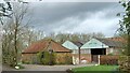
Husthwaite, Baxby Manor
According to the OS benchmark database there is a benchmark cut into the south-west face of the large farm building at the Manor. These are private grounds and no search was made.
Image: © Mel Towler
Taken: 23 Mar 2023
0.02 miles
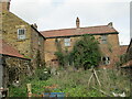
2

Baxby Manor
Claims to have been built in 1308, and is currently the centre of a glamping enterprise including hobbit holes for those of a vivid or curious imagination
Image: © Chris Heaton
Taken: 6 Nov 2018
0.04 miles
3
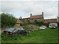
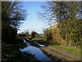
Abandoned cars at Baxby Mill
Three cars and a caravan abandoned at Baxby Mill.
Image: © T Eyre
Taken: 28 Apr 2014
0.08 miles
4
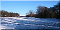
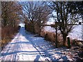
Footpath to Elphin Bridge
Footpath near Husthwaite village. The line of small trees to the left mark the line of the former railway track, whilst the taller trees to the right line the banks of Ings Beck.
Image: © Gordon Hatton
Taken: 24 Dec 2010
0.08 miles
6
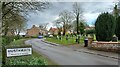
Footpath sign, Ings Lane
Several possibilities are indicated by this signpost on Ings Lane at the edge of Husthwaite village.
Image: © Gordon Hatton
Taken: 24 Dec 2010
0.09 miles
7
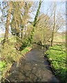
Elphin Beck
This beck drains a small area at the western end of the Howardian Hills and at some point eventually joins the Ouse.
Image: © Gordon Hatton
Taken: 26 Mar 2020
0.12 miles
8
Remains of railway bridge near to Baxby Manor
Image: © Phil Catterall
Taken: 2 Mar 2007
0.14 miles
9
Husthwaite, Low Street, cemetery
There is a benchmark cut into the north-west face of the cemetery wall and is to the right of the gate and post.
Image: © Mel Towler
Taken: 23 Mar 2023
0.15 miles
10
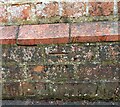
Husthwaite, Low Street, cemetery
The benchmark is cut into the north-west face of the cemetery wall and is to the right of the gate and post.
Image: © Mel Towler
Taken: 23 Mar 2023
0.15 miles