IMAGES TAKEN NEAR TO
Foston, YORK, YO60 7QD
Introduction
This page details the photographs taken nearby to YO60 7QD by members of the Geograph project.
The Geograph project started in 2005 with the aim of publishing, organising and preserving representative images for every square kilometre of Great Britain, Ireland and the Isle of Man.

There are currently over 7.5m images from over14,400 individuals and you can help contribute to the project by visiting https://www.geograph.org.uk
Image Map
Images are licensed for reuse under creativecommons.org/licenses/by-sa/2.0
Notes
- Clicking on the map will re-center to the selected point.
- The higher the marker number, the further away the image location is from the centre of the postcode.
Image Listing (3 Images Found)
Images are licensed for reuse under creativecommons.org/licenses/by-sa/2.0
Image
Details
Distance
1
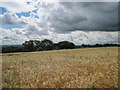
Barley field to Gower Hall Farm
The farm is nestled in the trees, storm clouds are starting to appear in the sky.
Image: © Martin Dawes
Taken: 11 Jul 2012
0.08 miles
3
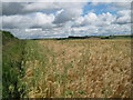
Barley and Wild Oats on the Bridleway to Stittenham Hill
Image: © Martin Dawes
Taken: 11 Jul 2012
0.17 miles