
IMAGES TAKEN NEAR TO
Hockley Crescent, YORK, YO51 9FN
Introduction
This page details the photographs taken nearby to Hockley Crescent, YO51 9FN by members of the Geograph project.
The Geograph project started in 2005 with the aim of publishing, organising and preserving representative images for every square kilometre of Great Britain, Ireland and the Isle of Man.

There are currently over 7.5m images from over14,400 individuals and you can help contribute to the project by visiting https://www.geograph.org.uk
Image Map
Images are licensed for reuse under creativecommons.org/licenses/by-sa/2.0
Notes
- Clicking on the map will re-center to the selected point.
- The higher the marker number, the further away the image location is from the centre of the postcode.
Image Listing (65 Images Found)
Images are licensed for reuse under creativecommons.org/licenses/by-sa/2.0
Image
Details
Distance
1

The Ure in flood at Boroughbridge
Boroughbridge is always vulnerable to winter flooding of the River Ure, which can rise rapidly after heavy rain over the dales.
Image: © Gordon Hatton
Taken: Unknown
0.05 miles
2
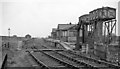
Boroughbridge Station (remains)
View NE, towards Pilmoor; ex-NER Pilmoor - Knaresborough branch, which was closed as early as 25/9/50, although open for goods Brafferton - Knaresborough until 5/10/64. (The two large water-tanks are prominent).
Image: © Ben Brooksbank
Taken: 19 Apr 1961
0.05 miles
3
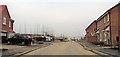
New housing, Milby
A large housing development on the northern side of Boroughbridge, extending from the B6265 across to the Milby road. This area is within the parish of Milby, but might be considered to be in Boroughbridge, Langthorpe or even Kirby Hill.
Image: © Gordon Hatton
Taken: 14 Jan 2018
0.09 miles
4
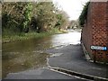
An aptly named road
Waterside is quite some way from the River Ure on the Langthorpe side, but on the 6th December 2015 the river burst its banks and edged along the B6265 after heavy and continuous rains in the dales.
Image: © Gordon Hatton
Taken: 6 Dec 2015
0.13 miles
5
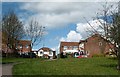
Market Hill housing development
Built on the site of the former Boroughbridge livestock mart, this nineties development stands just within Milby parish.
Image: © Gordon Hatton
Taken: 24 Apr 2008
0.13 miles
6
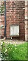
Boroughbridge, 1 Station View
Can I see part of an OS Datum line to the left of the key slot of the white meter box? The full benchmark on this wall has been lost to the installation of the meter box.
Image: © Mel Towler
Taken: 13 Mar 2022
0.14 miles
7
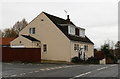
The Smithy
Close by Market Hill in Boroughbridge.
Image: © David Rogers
Taken: 23 Jan 2010
0.14 miles
8
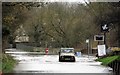
Ploughing through the waters
This Land Rover was able to cope with the foot or so of floodwater on the B6265 on the Langthorpe side of the Ure near Boroughbridge. The flood was the result of heavy and continuous rain some 50 miles upstream in Wensleydale, the Boroughbridge area having had little more than showers over the same period.
Image: © Gordon Hatton
Taken: 6 Dec 2015
0.14 miles
9
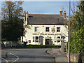
Grantham Arms Hotel
19th century public house on the north side of the river crossing at Boroughbridge.
Image: © Alan Murray-Rust
Taken: 5 Nov 2009
0.15 miles
10
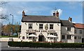
The Grantham Arms, Milby
Recently refurbished pub just across the river from Boroughbridge [and just within the parish of Milby]. The photographer is yet to sample the food and ale available within.
Image: © Gordon Hatton
Taken: 24 Apr 2008
0.16 miles