IMAGES TAKEN NEAR TO
Goodmanham Road, YORK, YO43 3HX
Introduction
This page details the photographs taken nearby to Goodmanham Road, YO43 3HX by members of the Geograph project.
The Geograph project started in 2005 with the aim of publishing, organising and preserving representative images for every square kilometre of Great Britain, Ireland and the Isle of Man.

There are currently over 7.5m images from over14,400 individuals and you can help contribute to the project by visiting https://www.geograph.org.uk
Image Map
Images are licensed for reuse under creativecommons.org/licenses/by-sa/2.0
Notes
- Clicking on the map will re-center to the selected point.
- The higher the marker number, the further away the image location is from the centre of the postcode.
Image Listing (43 Images Found)
Images are licensed for reuse under creativecommons.org/licenses/by-sa/2.0
Image
Details
Distance
1
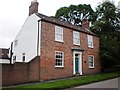
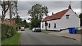
Grove Farm, Goodmanham
This shows the farmhouse of Grove Farm, situated along the main street through the village of Goodmanham.
Image: © Dr Patty McAlpin
Taken: 7 Aug 2009
0.05 miles

3
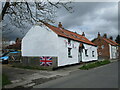
Goodmanham. Brockenhirst. Late C17 stone cottage
Image: © Martin Dawes
Taken: 1 May 2023
0.05 miles
4
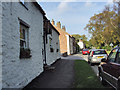
Goodmanham Road
Looking towards the village centre
Image: © Paul Harrop
Taken: 12 Oct 2008
0.06 miles
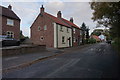
7
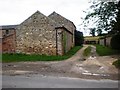
Entrance to The Elms Farm
This shows the entrance to The Elms Farm at Goodmanham, located along the main road through the village.
Image: © Dr Patty McAlpin
Taken: 7 Aug 2009
0.07 miles
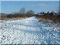
8
Southern fence across the railway embankment, Goodmanham
In August 2019 this fence [one of two] was erected across the route of the former Market Weighton - Driffield railway. On 21st April 2021 the path along the embankment which was blocked by the fences was added to the local council's public footpath network, and signs were put up at the nearest footpath junctions to publicise this change. Reading the signs, the photographer tried to walk the new public footpath on 23rd April 2021.
Image: © Christine Johnstone
Taken: 23 Apr 2021
0.12 miles
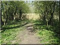
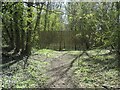
9
Disused Railway - Market Weighton.
A view East along the trackbed of the old Market Weighton to Beverley Railway. Opened in 1865 and closed 100 years later this is now an 11 mile public footpath linking the two towns.
Image: © Paul Allison
Taken: Unknown
0.16 miles
10
Northern fence across the railway embankment, Goodmanham
In August 2019 this fence [one of two] was erected across the route of the former Market Weighton - Driffield railway. On 21st April 2021 the path along the embankment which was blocked by the fences was added to the local council's public footpath network, and signs were put up at the nearest footpath junctions to publicise this change. Reading the signs, the photographer tried to walk the new public footpath on 23rd April 2021.
Image: © Christine Johnstone
Taken: 23 Apr 2021
0.17 miles