IMAGES TAKEN NEAR TO
Cliffe Road, YORK, YO43 3HF
Introduction
This page details the photographs taken nearby to Cliffe Road, YO43 3HF by members of the Geograph project.
The Geograph project started in 2005 with the aim of publishing, organising and preserving representative images for every square kilometre of Great Britain, Ireland and the Isle of Man.

There are currently over 7.5m images from over14,400 individuals and you can help contribute to the project by visiting https://www.geograph.org.uk
Image Map
Images are licensed for reuse under creativecommons.org/licenses/by-sa/2.0
Notes
- Clicking on the map will re-center to the selected point.
- The higher the marker number, the further away the image location is from the centre of the postcode.
Image Listing (9 Images Found)
Images are licensed for reuse under creativecommons.org/licenses/by-sa/2.0
Image
Details
Distance
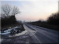
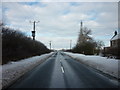
2

Road to North Cliffe
The red sign suggests drive with care due to pheasants. In my experience of pheasants on the road that is difficult to achieve.
Image: © David Brown
Taken: 20 Jan 2019
0.02 miles
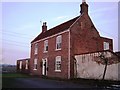
3
Passing Crossfield House
Looking along Cliffe Road.
Image: © DS Pugh
Taken: 20 Jun 2020
0.02 miles
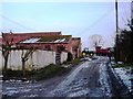
5
Road to North Cliffe
Taken from outside Crossfield House Farm
Image: © Martin Dawes
Taken: 4 Feb 2009
0.07 miles
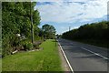
6
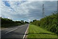
Electric cables over Cliffe Road
Looking along Cliffe Road in the direction of Market Weighton.
Image: © DS Pugh
Taken: 20 Jun 2020
0.07 miles
8
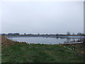
Reservoir near Market Weighton
Several similar in the area-reservoir and flood protection?
Image: © David Brown
Taken: 20 Jan 2019
0.09 miles
9
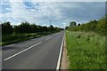
Along Cliffe Road
Looking in the direction of Market Weighton.
Image: © DS Pugh
Taken: 20 Jun 2020
0.17 miles