IMAGES TAKEN NEAR TO
Sancton Road, YORK, YO43 3DB
Introduction
This page details the photographs taken nearby to Sancton Road, YO43 3DB by members of the Geograph project.
The Geograph project started in 2005 with the aim of publishing, organising and preserving representative images for every square kilometre of Great Britain, Ireland and the Isle of Man.

There are currently over 7.5m images from over14,400 individuals and you can help contribute to the project by visiting https://www.geograph.org.uk
Image Map
Images are licensed for reuse under creativecommons.org/licenses/by-sa/2.0
Notes
- Clicking on the map will re-center to the selected point.
- The higher the marker number, the further away the image location is from the centre of the postcode.
Image Listing (57 Images Found)
Images are licensed for reuse under creativecommons.org/licenses/by-sa/2.0
Image
Details
Distance
1
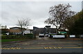
St Mary's Roman Catholic Primary School, Market Weighton
On Sancton Road.
Image: © JThomas
Taken: 18 Nov 2021
0.00 miles
2

St Mary's RC School, Market Weighton
Showing the changes since the extension and rebuilding work at the school between 2006 and 2008. Compare with Image to see extent of changes.
Image: © Paul Harrop
Taken: 23 Aug 2008
0.01 miles
3
Sancton Road, Market Weighton
Approaching the A1079 by-pass.
Image: © JThomas
Taken: 18 Nov 2021
0.04 miles
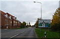
4

Sancton Road, Market Weighton
Towards the A1079 by-pass.
Image: © JThomas
Taken: 18 Nov 2021
0.05 miles

6
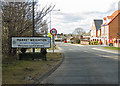
the heart of east yorkshire
So reads the sign - would have preferred upper case where required. Sancton Road approach to Market Weighton. (pronounced Weeton)
Image: © Pauline E
Taken: 5 Apr 2013
0.06 miles
7
St Mary's RC School, Market Weighton
Situated on Sancton Road in Market Weighton, East Yorkshire.
Image: © Colin Westley
Taken: 31 May 2004
0.06 miles
8
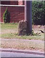
Old Milestone by Sancton Road, Market Weighton
Carved stone post by the UC road, in parish of MARKET WEIGHTON (EAST RIDING OF YORKSHIRE District), Sancton Road, Market Weighton, by telegraph pole on well cut grass verge, on West side of road, opposite Langdale Road. Erected by an unknown authority in the 18th/19th century.
Inscription once read:-
(South Cave)
(7)
It once had a carved bench mark.
Milestone Society National ID: YE_SVMW08.
Image: © J Harland
Taken: 1 Jun 2001
0.08 miles
9
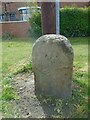
Old milestone
This very eroded milestone by Telegraph Pole DP132 on Sancton Road in Market Weighton has no visible remnants of an inscribed legend or that a plate had been attached. On the 1910 map it is noted as 'Old MS'. It is on the route of the continuation of the Brough Ferry and Newbold Holmes turnpike operative between 1771 and 1872.
Image: © Chris Minto
Taken: 10 Apr 2022
0.08 miles
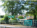
10
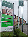
King's Court, Market Weighton
New housing development off Sancton Road on the south-eastern edge of the town.
Image: © Paul Harrop
Taken: 23 Aug 2008
0.08 miles