IMAGES TAKEN NEAR TO
Storwood, YORK, YO42 4TD
Introduction
This page details the photographs taken nearby to YO42 4TD by members of the Geograph project.
The Geograph project started in 2005 with the aim of publishing, organising and preserving representative images for every square kilometre of Great Britain, Ireland and the Isle of Man.

There are currently over 7.5m images from over14,400 individuals and you can help contribute to the project by visiting https://www.geograph.org.uk
Image Map (Loading...)


Getting Data...Please wait
Leaflet Map data © OpenStreetMap
Images are licensed for reuse under creativecommons.org/licenses/by-sa/2.0
Notes
- Clicking on the map will re-center to the selected point.
- The higher the marker number, the further away the image location is from the centre of the postcode.
Image Listing (4 Images Found)
Images are licensed for reuse under creativecommons.org/licenses/by-sa/2.0
Image
Details
Distance
3
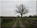
Track to Ball Hall caravan site
This area has several recreational sites. The land is poor but the area attractive.
Image: © Jonathan Thacker
Taken: 17 Feb 2017
0.22 miles
4
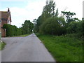
Towards Ballhall Farm
Looking along Ballhall Lane.
Image: © DS Pugh
Taken: 11 Aug 2012
0.23 miles