IMAGES TAKEN NEAR TO
Thornton, Melbourne, YORK, YO42 4RJ
Introduction
This page details the photographs taken nearby to YO42 4RJ by members of the Geograph project.
The Geograph project started in 2005 with the aim of publishing, organising and preserving representative images for every square kilometre of Great Britain, Ireland and the Isle of Man.

There are currently over 7.5m images from over14,400 individuals and you can help contribute to the project by visiting https://www.geograph.org.uk
Image Map
Images are licensed for reuse under creativecommons.org/licenses/by-sa/2.0
Notes
- Clicking on the map will re-center to the selected point.
- The higher the marker number, the further away the image location is from the centre of the postcode.
Image Listing (9 Images Found)
Images are licensed for reuse under creativecommons.org/licenses/by-sa/2.0
Image
Details
Distance
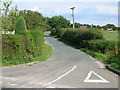
2
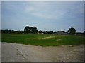
Willow Tree Farm
Seen from the narrow road running towards the Pocklington canal.
Image: © DS Pugh
Taken: 25 May 2009
0.03 miles
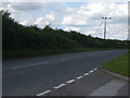
7

Protecting the road
Work was being undertaken on the 400 kV transmission lines, and this scaffold structure has been erected to protect the road in the event of the lines dropping.
Image: © DS Pugh
Taken: 21 Jul 2013
0.15 miles
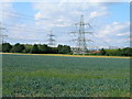
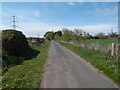
9
View towards Pinewood Farm
The Yorkshire Wolds in the distance.
Image: © Jonathan Thacker
Taken: 28 Dec 2017
0.24 miles