IMAGES TAKEN NEAR TO
Park Close, YORK, YO42 4QR
Introduction
This page details the photographs taken nearby to Park Close, YO42 4QR by members of the Geograph project.
The Geograph project started in 2005 with the aim of publishing, organising and preserving representative images for every square kilometre of Great Britain, Ireland and the Isle of Man.

There are currently over 7.5m images from over14,400 individuals and you can help contribute to the project by visiting https://www.geograph.org.uk
Image Map (Loading...)


Getting Data...Please wait
Leaflet Map data © OpenStreetMap
Images are licensed for reuse under creativecommons.org/licenses/by-sa/2.0
Notes
- Clicking on the map will re-center to the selected point.
- The higher the marker number, the further away the image location is from the centre of the postcode.
Image Listing (15 Images Found)
Images are licensed for reuse under creativecommons.org/licenses/by-sa/2.0
Image
Details
Distance
1
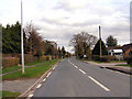
Melbourne
The B1228 approaching Melbourne.
Image: © David Dixon
Taken: 5 Apr 2010
0.09 miles
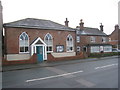
2
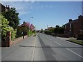
The Barn in Melbourne
Looking along the village of Melbourne, East Yorkshire.
Image: © DS Pugh
Taken: 17 Apr 2011
0.09 miles
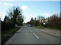
5

Start of Kidd Lane
Looking along Kidd Lane in Melbourne.
Image: © DS Pugh
Taken: 22 Apr 2017
0.16 miles

7
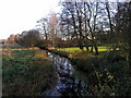
Black Drain
This land drainage channel runs parallel with the Pocklington Canal.
Image: © Andy Beecroft
Taken: 17 Dec 2006
0.18 miles
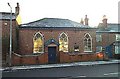
8
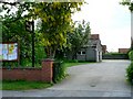
Melbourne Wesleyan Chapel
Dates from 1811.
Image: © Jonathan Thacker
Taken: 2 Jan 2013
0.21 miles
9
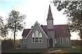
Melbourne, former Church of St Monica
This building is not now used as a church. It is a private residence.
Image: © Bill Henderson
Taken: Unknown
0.21 miles