IMAGES TAKEN NEAR TO
Seaton Ross, YORK, YO42 4NG
Introduction
This page details the photographs taken nearby to YO42 4NG by members of the Geograph project.
The Geograph project started in 2005 with the aim of publishing, organising and preserving representative images for every square kilometre of Great Britain, Ireland and the Isle of Man.

There are currently over 7.5m images from over14,400 individuals and you can help contribute to the project by visiting https://www.geograph.org.uk
Image Map
Images are licensed for reuse under creativecommons.org/licenses/by-sa/2.0
Notes
- Clicking on the map will re-center to the selected point.
- The higher the marker number, the further away the image location is from the centre of the postcode.
Image Listing (26 Images Found)
Images are licensed for reuse under creativecommons.org/licenses/by-sa/2.0
Image
Details
Distance
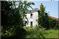
2
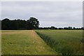
Towards White House Farm
Looking from the Scamland road.
Image: © DS Pugh
Taken: 21 Jul 2013
0.04 miles
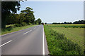
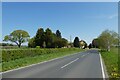
4
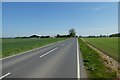
Road near White House Farm
Looking along the road towards Seaton Ross.
Image: © DS Pugh
Taken: 30 Apr 2022
0.07 miles
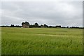
5
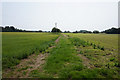
Farmland opposite White House Farm
Along the road to Seaton Ross.
Image: © DS Pugh
Taken: 21 Jul 2013
0.07 miles
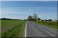
7
Road from Seaton Ross
Looking along the road leading to Everingham.
Image: © DS Pugh
Taken: 30 Apr 2022
0.12 miles
8
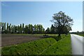
Approaching Rytham Gate
Looking along a drain beside the road from Scamland.
Image: © DS Pugh
Taken: 30 Apr 2022
0.13 miles
9
Road junction at Rytham Gate
Looking towards the road junction. Ahead leads to Everingham.
Image: © DS Pugh
Taken: 30 Apr 2022
0.14 miles
10
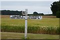
Signpost from the Scamland road
Signing Everingham, Market Weighton, Seaton Ross, Howden, Melbourne and Pocklington.
Image: © DS Pugh
Taken: 21 Jul 2013
0.15 miles